

PM Modi Inaugurates Ahmedabad-Dholera Expressway
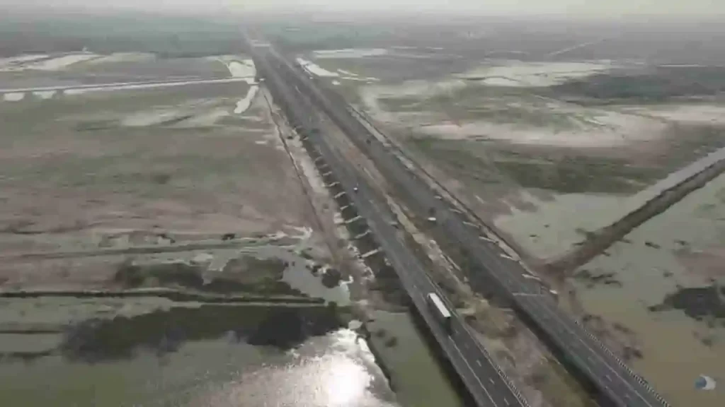
Imagine zipping from the bustling heart of Ahmedabad to the rising star of Dholera in just 45 minutes, instead of a bumpy two-hour crawl. That dream roared to life on Tuesday when Prime Minister Narendra Modi cut the ribbon on the stunning Ahmedabad-Dholera Expressway, a sleek, Rs 5,100 crore marvel of engineering that’s set to supercharge Gujarat’s economy.These developments focus on roads, railways, semiconductors, renewable energy, and urban mobility.Ahmedabad-Dholera Expressway Now OpenPM Modi inaugurated the Ahmedabad-Dholera Expressway on March 31.Cost: Over Rs 5,100 crore.Type: Access-controlled highway.Length: Approximately 110 km.Travel time: Reduces from 2 hours to 45 minutes.Speed limit: Up to 120 kmph.Benefits: Improves connectivity to Dholera Special Investment Region (DSIR), boosts industrial growth, and supports economic development.Road and Highway ProjectsThe Prime Minister laid foundation stones for key road upgrades:Four-lane Idar-Badoli bypass with paved shoulders.Upgrade of Dholavira–Mauvana–Vauva–Santalpur section (Package II) of National Highway 754K to a two-lane with paved shoulders.These projects aim to reduce travel time, enhance safety, and support logistics.Flyovers for Urban Traffic ReliefTwo flyovers were addressed to ease congestion in Gandhinagar and Ahmedabad:Inaugurated: Flyover at PDPU Junction on Gandhinagar-Koba-Ahmedabad Airport Road (handles over 1.4 lakh vehicles daily).Foundation laid: Flyover at Bhaijipura Junction on Gandhinagar-Koba-Airport Road (includes parking facilities below).These will cut commute times to the airport and state capital.Keynes Semicon Plant InauguratedPM Modi inaugurated the Keynes Semicon plant in Sanand, Ahmedabad.Milestone: Second semiconductor plant in India to start commercial manufacturing.Initial product: Advanced Intelligent Power Modules (IPMs) with 17 chips each.Applications: Automotive and industrial power systems.Client: Alpha & Omega Semiconductor (California-based).Full capacity: 6.33 million units per day.This strengthens India’s semiconductor sector.Railway Infrastructure UpgradesDedicated to the nation:Kanalus-Jamnagar doubling project (28 km, part of 111.20 km Rajkot-Kanalus project).Quadrupling of the Gandhidham–Adipur section (10.69 km).These improve train frequency and freight movement.Renewable Energy BoostPM Modi inaugurated Khavda Pooling Station-2 and associated transmission systems.Capacity: Evacuates 4.5 GW of renewable energy.Role: Supports Gujarat’s solar and wind power grid.Gujarat now leads India in solar power generation, as highlighted by the PM.PM Modi’s Remarks on Gujarat’s ProgressDuring the public address, PM Modi highlighted Gujarat’s leadership in renewable energy. He recalled establishing a multi-technology solar park in 2010 as Chief Minister, which laid the foundation for the state’s solar growth.Broader ImpactThe projects cover connectivity, industry, green energy, healthcare, and tourism. They align with national goals for infrastructure and sustainable development. Official sources confirm all details from the Prime Minister’s Office and the Gujarat government announcements.
From Power Corridors to Cultural Eternity: Yuge Yugeen Bharat Museum as World’s Largest by 2026

In a transformative pivot from colonial legacies to civilizational pride, India’s historic North and South Blocks on Raisina Hill are shedding their administrative mantle to birth the Yuge Yugeen Bharat Museum, poised to claim the title of the world’s largest museum. Spanning 1.55 lakh square meters (with over 80,000 sqm of display space across 950 rooms), this behemoth will chronicle 5,000 years of Bharat’s journey, from Indus Valley seals to modern manuscripts. The first gallery is expected to open in the North Block by late 2026, featuring 30 thematic spaces over three years and showcasing 80,000–1 lakh artefacts sourced from national vaults, state collections, and ASI treasures.Culture Secretary Vivek Aggarwal revealed to The Times of India: the inaugural “Time and Timelessness” gallery will spotlight 100 pivotal relics – think Indus Valley terracotta hourglasses (2500–1750 BCE), Mauryan edict pillars (3rd century BCE), Gupta Surya sculptures (5th century CE), the iconic 13th-century Konark Sun Wheel, and Chola Nataraja bronzes (10th–11th century CE) – offering a philosophical portal into India’s eternal ethos.Colonial Bastions Reborn: North-South Blocks’ Historic ShiftOnce the nerve center of British Viceregal power and post-Independence governance, these Edwin Lutyens-designed edifices witnessed the scars of Partition, Emergency deliberations, and triumphs such as the GST rollout, the abrogation of Article 370, and Swachh Bharat. For 95 years, South Block housed the PMO under 16 leaders from Nehru to Modi; Cabinet meetings echoed here until February 2026’s poignant finale.PM Modi’s February 13 dedication of the new PMO, rechristened ‘Seva Teerth’, alongside ‘Kartavya Bhavans’ signaled the epochal change. Ministries like Home, Finance, Personnel, External Affairs, and CBI have relocated to these tech-savvy, green workspaces on Kartavya Path, freeing the blocks for “adaptive reuse.” The Union Cabinet hailed it as a leap from “power-centric” rule to “service-oriented” Viksit Bharat, preserving architecture while infusing modern museology.Thematic Tapestry: 5,000 Years in 30 GalleriesCurated across eight zones, the museum weaves politics, art, spirituality, and innovation:Ancient Foundations: Indus artefacts from Kalibangan, Harappan seals.Classical Glory: Mauryan edicts, Gupta gold coins, Ajanta murals.Medieval Majesty: Chola bronzes, Vijayanagara scrolls, Mughal miniatures.Freedom to Future: INA trials, Constitution drafts, space tech replicas.Expect immersive audio-visuals, digital holograms, manuscripts, coins, and murals, all from a mapped pool of 20 lakh objects. Indo-French synergy elevates it: a December 2024 pact with France Museums Development pairs India’s heritage with Louvre-caliber expertise. Arcop Associates leads design under Thai architect Kulapat Yantrasast (Louvre redeveloper, LA’s Academy Museum), blending adaptive heritage with UNESCO/ICOM standards.Seamless Spectacle: Engineering Visitor DreamsAnticipating 10 million annual visitors (50,000 daily), accessibility reigns: ramps for PwD, seamless flows sans Raisina security snarls. A proposed underground tunnel – morphing into a subterranean cultural corridor- will link North-South Blocks, letting explorers glide between eras undetected. Restoration strips post-Independence partitions, reviving Lutyens’ grandeur amid sustainable tech. Culture Minister Gajendra Shekhawat eyes first verticals by 2027, eclipsing the Louvre’s footprint.FeatureYuge Yugeen BharatLouvre (Paris)Total Area1.55 lakh sqm~72,735 sqmDisplay Space80,000+ sqm~40,000 sqmArtefacts80,000–1 lakh~380,000 (38,000 displayed)Timeline Span5,000 years (Indus–Modern)10,000 years (global)Galleries30 across 8 zones35+ departmentsAnnual VisitorsProjected 10 million9.6 million (2024) Tourism Tsunami and Legacy LinkThis Central Vista crown jewel joins the PM Museum and digitised Archives, amplifying cultural mapping. Replacing Janpath’s National Museum, it repositions Delhi as a heritage hub, drawing global gazes to Raisina’s reinvention. As North Block readies its debut, Yuge Yugeen Bharat isn’t exhibiting; it’s Bharat’s soul, timeless and triumphant, inviting generations to reclaim their continuum.
Mumbai-Pune Missing Link Now Open: World’s Widest Tunnel Ends Ghat Nightmares
The Mumbai-Pune Expressway’s Missing Link opened on May 2, 2026. This 13.3-km engineering marvel now carries traffic smoothly. It skips the dangerous Khandala Ghat with its hairpin turns and traffic jams. The Maharashtra State Road Development Corporation (MSRDC) finished the project just in time for Maharashtra Day. Deputy Chief Minister Eknath Shinde cut the ribbon. Vehicles now zip through in 25-30 minutes less time. Safe speeds reach 120 km/h. The main tunnel holds a Guinness World Record as the widest highway tunnel on the planet. The old ghat section tortured drivers for years. Trucks clogged narrow lanes. Families slept in cars overnight. Ambulances crawled slowly. Landslides hit during monsoons. The new link brings huge relief. It starts at Khalapur toll plaza on the Mumbai side. It ends at Kusgaon near Lonavala and Sinhagad Institute. Total distance shortens by 6 km. Over 50,000 vehicles use the expressway daily. This bypass makes travel faster and safer for everyone.Stunning Engineering: Tunnels, Bridges, and Safety FeaturesThe Missing Link blends cuts, tunnels, viaducts, and flyovers. It features eight lanes with full access control. No more slow trucks in the way.Twin Tunnels Shine BrightTunnel 1 stretches 8.7 km long. Its internal width measures 23.5 meters. This makes it the world’s widest highway tunnel. Guinness confirmed the record after inspectors visited. Tunnel 2 runs 1.67 km. Both handle bidirectional traffic. Each side has four lanes plus shoulders and emergency areas. Fire-proof walls protect users. Jet fans ventilate air. CCTV watches every spot. SOS phones sit every 500 meters. Teams finished electrical and mechanical testing right before opening.Cable-Stayed Bridge Steals the ShowThis bridge spans 650 to 950 meters. Its deck sits 100-125 meters high. The pylon towers 183 meters total. It withstands winds up to 250 km/h. Workers erected the girder in March 2026. They completed 98% of the deck slab. It’s now Maharashtra’s tallest bridge of this type.Other Key PartsA 900-meter viaduct rises 60 meters high. Cut-and-cover tunnels ease tight spots. Flyovers speed up joins. Toll plazas at Khalapur, Talegaon, and Shedung got wider. Hazardous cargo bans keep tunnels safe. No heavy trucks or gas tankers allowed inside.ComponentLength/SizeStatus (May 2026)Key FactMain Tunnel8.7 km, 23.5m wideFully OpenGuinness World RecordEscape Tunnel1.67 kmFully OpenTop Safety FeatureCable Bridge650-950m, 183m tallFully OpenTallest in MaharashtraViaduct900mFully Open60m HighOverall Project13.3 km100% CompleteOpen Since May 1Long Road of Delays Ends in TriumphPlanning started in 2018 with a budget of Rs 6,695 crore. Delays piled up from weather, tough terrain, and COVID. Targets slipped from March 2024 to January 2025, then September and December 2025. Finally, April 30 marked civil works done. Trials followed quickly. MSRDC pushed 2,000 workers hard. Over 1,500 focused on tunnels alone. They worked round the clock.Recent chaos sped things up. Ram Navami traffic jams and tanker flips trapped thousands. MNS chief Raj Thackeray criticized slow work. Deputy CM Shinde ordered emergency plans. MSRDC MD Anilkumar Gaikwad promised action. “Civil works wrap by April 30; trials follow,” he said. The team delivered.Toll collection starts in 2030 for 15 years. It recovers costs over time. Slight toll hikes come with the expressway upgrade. Drivers agree the value beats the price.Relief Replaces Ghat Horror StoriesThe 19.8-km Khopoli-Khandala Ghat had 24 sharp bends. Narrow lanes mixed cars and trucks. Monsoon landslides closed roads often. Kids missed school. Patients reached hospitals late. Ambulances fought for space. One tanker crash blocked traffic for 32 hours. Families ran out of food and water.Now, the Missing Link changes everything. No more ghat climbs. Straighter inland paths replace twists. Safer barriers and lighting guide drivers. Higher speeds cut travel time. Pune-bound lanes opened first. Mumbai-bound finished the final 6 meters on time. Families cheer the smooth ride.Part of Maharashtra’s Road BoomThis project fits Deputy CM Devendra Fadnavis’ big infra plans. The Samruddhi Mahamarg sets records too. MSRDC leads India’s road revolution. The Missing Link connects futures. It saves time, cuts accidents, and boosts business. Trucks move goods faster. Tourists reach Lonavala easy. Daily commuters gain hours weekly.Two days after opening, drivers share joy online. No jams. Quick trips. Safe paths. The ghat nightmare fades. Concrete and steel reclaimed lives. Maharashtra celebrates a new era of fast, safe travel. The world’s widest tunnel proves Indian engineering rules the road.
Raipur-Vizag Expressway: Forests and Hills to Link Heartland to Coast in 6 Hours Flat

India’s infrastructure revolution accelerates with the Raipur–Visakhapatnam Expressway (NH-130CD), a 464-km six-lane greenfield marvel threading Chhattisgarh’s forests, Odisha’s mineral belts, and Andhra Pradesh’s Eastern Ghats. Slated for December 2026 completion at ₹16,482–20,000 crore under Bharatmala Pariyojana Phase-I, this Economic Corridor (EC-15) shrinks the 595-km NH-26 slog – from 12–13 hours to just 5–7 hours – fueling exports, tourism, and tribal upliftment.Prime Minister Narendra Modi laid the foundation stone in November 2022, igniting construction across 19 packages via the Hybrid Annuity Model (HAM). South Korean firm YONGMA Engineering crafted the Detailed Project Report (DPR), with most stretches under active build by giants like Dilip Buildcon, HG Infra, Adani Transport, and NKC Projects. Tunnels pierce Ghat valleys – a 2.9-km twin bore in Koraput nears 90% completion, boasting jet fans, fire systems, and SOS every 200m.Route Breakdown: From Abhanpur to SabbavaramKicking off at Kurud/Abhanpur (Raipur district) on NH-30/NH-130C/SH-22, it slices southeast:Chhattisgarh (4 districts, ~125 km)Raipur → Dhamtari (Package-1: Abhanpur-Magerlod, Shalimar Corp.)Kanker (Package-2: Sargi-Basanwahi, Dilip Buildcon; via Sarona)Kondagaon (east of Keskal)Border at Marangpuri/Salna (Package-3: KMV Projects)Odisha (2 districts, ~214 km)Nabarangpur (Packages 1–4: Sunapali-Raighar-Umerkote-Nabarangpur; NKC, Barbrik, Adani)Koraput (Packages 5–11: Borigumma-Dasamantpur-Koraput-Sunabeda-Pottangi; HG Infra, DRA Infracon; 3 pending notices). Tunnels and noise barriers shield Indravati National Park greenery.Andhra Pradesh (Vizianagaram-Visakhapatnam, ~125 km)Parvathipuram Manyam-Vizianagaram (Packages 1–3: Aluru-Jakkuva-Korlam-Kantakapalle; HG Infra, NKC, PSK)Ends at Sabbavaram Interchange on NH-16 Golden Quadrilateral, linking Visakhapatnam Port. ROB over Araku rail line; land hurdles linger in final stretches.Access-controlled for 100 km/h speeds, it hugs NH-26 strategically, with sustainable medians, tree-lined edges, and Ghat eco-shields.SectionLength (km)Key PackagesProgress NotesChhattisgarh~1251–3Viaducts, earthwork advancingOdisha~2141–11Koraput tunnels 70–90%; Nabarangpur 70%AP~1251–4Interchange/Fastag ready; land acquisition delaysEconomic Lifeline: Ports, Minerals, and MarketsTethering Raipur’s steel-coal hub to Vizag Port slashes logistics costs, supercharging exports to East Asia (China, Japan, Korea). Mineral-rich Chhattisgarh-Odisha gain freight efficiency; industries sprout along spurs. Farmers hail land value surges – from ₹15 lakh/acre to ₹1.5 crore – with fair compensation fueling hope: “What we lost turns into a better future,” says Vizianagaram’s Srinivasulu. Truckers like Vishal foresee day trips: “One-and-a-half days to nighttime arrivals.” PM Gati Shakti vision integrates it with East Coast Corridor (Kolkata-Kanyakumari).infra.Tourism and Tribal TransformationUnlocks Dandakaranya’s hidden gems: Araku Valley coffee trails, Sitanadi/Indravati sanctuaries, Jagdalpur’s Chitrakoot Falls. Remote spots like Kanker, Koraput, and Borigumma integrate via faster access to markets/services, spawning jobs in hospitality, realty, and agro-processing.Future Web: National and Global ReachBharatmala spurs eye NCR-CMC links: Bathinda-Hisar-Jaipur-Gwalior (Chambal bridges); Ludhiana-Patiala-Narnaul-Alwar; Paradeep-Raxaul Eastern Corridor loop. Ties to Delhi-Mumbai Expressway, Yamuna Eway, Amritsar-Jamnagar – even Nepal – forge a pan-India artery.As cranes hum near Kothavalasa bridges, this corridor embodies Bharat’s build: not roads, but rivers of opportunity carving equity from terrain. By 2026, Raipur-Vizag won’t just connect – it’ll catalyze destinies.
Shiva’s Stadium: Varanasi’s New Cricket Temple Blends Mythology, Modernity, and Green Power
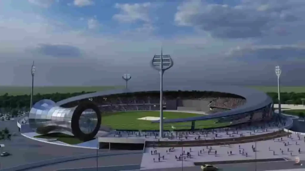
Amid the eternal ghats of Kashi, where Lord Shiva is said to have founded the city as his divine abode, a new landmark is emerging that marries cricket’s feverish passion with the city’s spiritual soul. The Varanasi International Cricket Stadium, under rapid construction in Gajari village (Raja Talab tehsil, 22 km from the sacred Dashashwamedh Ghat), promises to redefine sports venues in India. With a ₹452 crore price tag and a 30,000-seat capacity, this project, launched by Prime Minister Narendra Modi in September 2023, stands over 90% complete. District Magistrate Satyendra Kumar told ABP Live: “Construction is organized and on track for handover by late April, with floodlights up, premium grass turf installed, and seating finalized. Quality and Varanasi’s cultural heritage are priorities.”Divine Design: Every Element Echoes ShivaWhat sets this stadium apart is its immersive Shiva-themed architecture, turning a sports arena into a living tribute to ‘Bholenath.’ Viral images, shared by BJP leader @naveenjindalbjp on X, showcase trishul-shaped floodlights that pierce the skyline like Shiva’s weapon, igniting online buzz: “Perfect tribute to Lord Shiva in Kashi, the energy will be unmatched!” and “Trishul rules in Shivji ki Nagri.” The crescent-shaped canopy symbolizes the moon in Shiva’s jatamakuta (matted locks), while the dome-like media centre replicates the damru, his rhythmic instrument that beats the universe’s pulse. Outer walls feature intricate belpatra (bael leaf) motifs, sacred to Shiva, and the seating cascades in ghat-inspired steps, evoking the Ganga’s ritual stairs where devotees gather for aarti.BCCI Vice President Rajeev Shukla hailed it as visionary: “From Shiva-inspired architecture to solar-powered design, it represents sustainable, inclusive venues rooted in heritage.” This isn’t mere aesthetics; it’s cultural synergy. Varanasi, revered as Shiva’s earthly home in Hindu lore, now channels that mystique into cricket, blending the roar of crowds with the city’s devotional hum.Pitch Perfection and Cricketing NurseryAt the heart lies a state-of-the-art playing field with nine curated pitches: four red soil (for bounce and spin), three black soil (for seam movement), and two hybrid mixes. Modeled after top venues like Lucknow’s Ekana Stadium and Ahmedabad’s Narendra Modi Stadium, these offer versatile conditions to test international stars and hone domestic talent. The outfield uses premium grass with advanced sub-surface drainage, monsoon-proofed for uninterrupted play.Beyond the boundary, a dedicated cricket academy includes dormitories for 100 trainees – a boon for Uttar Pradesh’s budding players. UPCA officials envision it as North India’s next powerhouse, scouting from local maidans to global arenas.Green Revolution: Solar, Recycling, and EV PioneersSustainability is woven into the blueprint. Solar panels will power operations, slashing carbon footprints in a city grappling with Ganga pollution. A comprehensive water recycling system reuses rainwater and greywater for irrigation, aligning with national Swachh Bharat goals. Standout? An on-site EV recharging station, “We’re probably the first stadium to install one,” says a UPCA official, future-proofing for electric team buses and fan vehicles amid India’s green mobility push.These features position Varanasi as a model for eco-stadiums, especially as climate change threatens Indian pitches with erratic weather.Timeline and Trials: From Foundation to FloodlightsLaunched amid fanfare in 2023, progress accelerated post-2025 monsoons. Early 2026 saw structural steel framing complete, followed by roofing and electrics. Speculation swirled about IPL 2026 hosting, fueled by the April deadline, but UPCA clarified to TOI: “Not this season; focus is readiness for internationals.” Whispers of 2027 ODI World Cup matches add intrigue, with the venue eyeing BCCI approval for prime fixtures.Challenges? Logistical hurdles in rural Gajari were met with efficient supply chains, ensuring the April handover.A Game-Changer for Varanasi and Indian CricketFor Varanasi’s economy, reliant on tourism and festivals, it promises jobs, hospitality booms, and events blending cricket with bhajans or cultural nights. Nationally, it underscores PM Modi’s infrastructure vision: 11 new UP stadiums since 2017, elevating the state from backyard cricket to world-class hubs.
Vadhavan Port: India’s Next Mega Deep-Sea Gateway
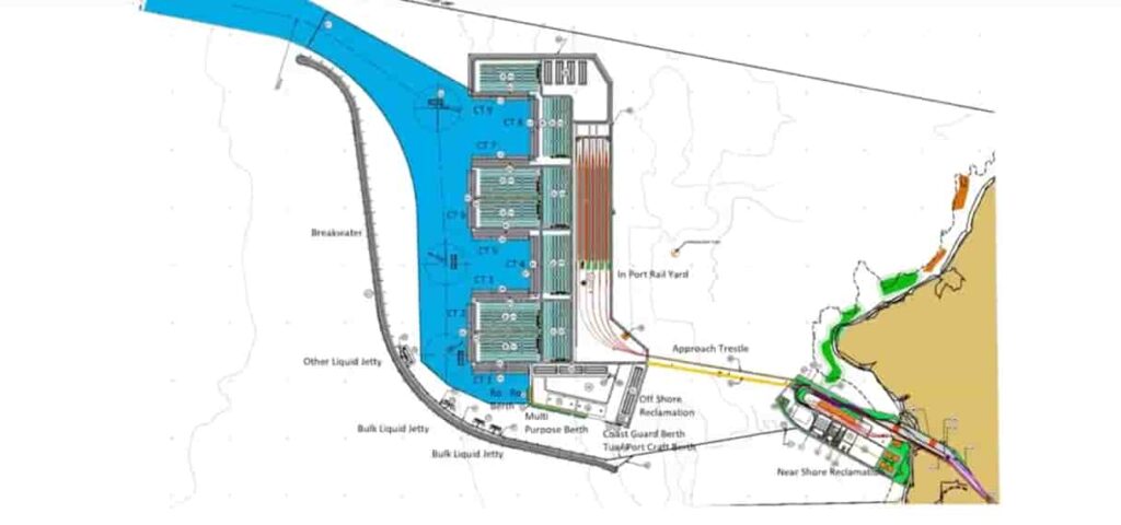
IntroductionThe Vadhavan Port Project is one of the most ambitious port development initiatives currently underway in the country. Planned along the western coastline near Dahanu, the project is being positioned as a world-class deep-sea port that will significantly enhance India’s maritime capacity and global trade competitiveness.At a time when India is aiming to become a major player in global supply chains, Vadhavan Port is expected to play a transformative role by handling ultra-large cargo vessels and reducing dependence on foreign transshipment hubs.Background and Strategic NeedIndia’s growing economy and increasing trade volumes have highlighted the limitations of existing ports, particularly in handling large container ships. A significant portion of India’s cargo is still transshipped through ports in countries like Singapore and Sri Lanka.The Vadhavan Port Project was conceptualised to address these gaps by creating a deep-draft port capable of accommodating next-generation container vessels. Its development aligns with national initiatives such as the Sagarmala Programme, which focuses on port-led development.Location and Project LayoutThe port is being developed near Dahanu in Maharashtra, strategically located along the Arabian Sea and close to major industrial and commercial hubs like Mumbai and Gujarat.The project is being executed by Jawaharlal Nehru Port Authority (JNPA), which already operates India’s largest container port at Nhava Sheva.Key aspects of the project include:Development of deep-draft berthsLarge-scale land reclamationModern cargo handling infrastructureRail and road connectivity to hinterland regionsKey Features and CapacityDeep-Sea CapabilityOne of the defining features of Vadhavan Port is its natural deep draft, which allows it to handle ultra-large container vessels (ULCVs) with capacities exceeding 20,000 TEUs. This will place the port among the most advanced in the world.Massive Cargo Handling CapacityOnce completed, the port is expected to have a capacity of over 200 million tonnes per annum, making it one of India’s largest ports.Advanced InfrastructureThe port will be equipped with:Automated cargo handling systemsSmart logistics and digital trackingDedicated freight corridorsThese features aim to ensure efficiency, speed, and global competitiveness.Economic SignificanceThe Vadhavan Port Project is expected to have far-reaching economic implications.Reduction in Logistics CostsBy enabling direct handling of large vessels, the port will reduce the need for transshipment through foreign ports, lowering logistics costs and saving time.Boost to Exports and TradeImproved port capacity and efficiency will strengthen India’s export capabilities and integration into global trade networks.Employment and Industrial GrowthThe project is expected to generate significant employment opportunities during both construction and operational phases. It will also promote industrial development in surrounding regions.Connectivity and IntegrationThe port is being designed with strong connectivity to major transport networks, including:National highwaysRailway freight corridorsIndustrial clustersThis integrated approach ensures seamless movement of goods from ports to inland markets.Environmental Concerns and OppositionDespite its economic potential, the project has faced strong opposition from environmental groups and local communities.Ecological ImpactConcerns have been raised about:Impact on marine biodiversityDamage to coastal ecosystemsEffects on fishing communitiesDahanu is considered an ecologically sensitive zone, which has intensified debates around the project.Legal and Regulatory ChallengesThe project has undergone extensive environmental scrutiny and regulatory processes. Balancing development with environmental sustainability remains a key challenge.Progress and Current StatusAs of 2026, the Vadhavan Port Project has received key approvals and is moving through various stages of planning and early development. Land acquisition, environmental clearances, and infrastructure planning are ongoing.The project is expected to be developed in phases over the coming years.Strategic Importance for IndiaVadhavan Port is not just another infrastructure project—it is a strategic initiative aimed at positioning India as a major maritime and logistics hub.By reducing dependence on foreign ports and enhancing domestic capacity, the project strengthens India’s economic sovereignty in global trade.It also complements other major infrastructure initiatives, including port modernisation and logistics reforms under national programmes.Final PerspectiveThe Vadhavan Port Project represents India’s long-term vision of building world-class maritime infrastructure capable of competing on a global scale. While it promises significant economic and strategic benefits, it also highlights the complexities of developing large-scale projects in environmentally sensitive regions.As the project progresses, its success will depend on how effectively it balances growth, sustainability, and the interests of local communities—making it one of the most closely watched infrastructure developments in the country.
Rameshwaram Folding Bridge: India’s First Vertical Lift Sea Bridge
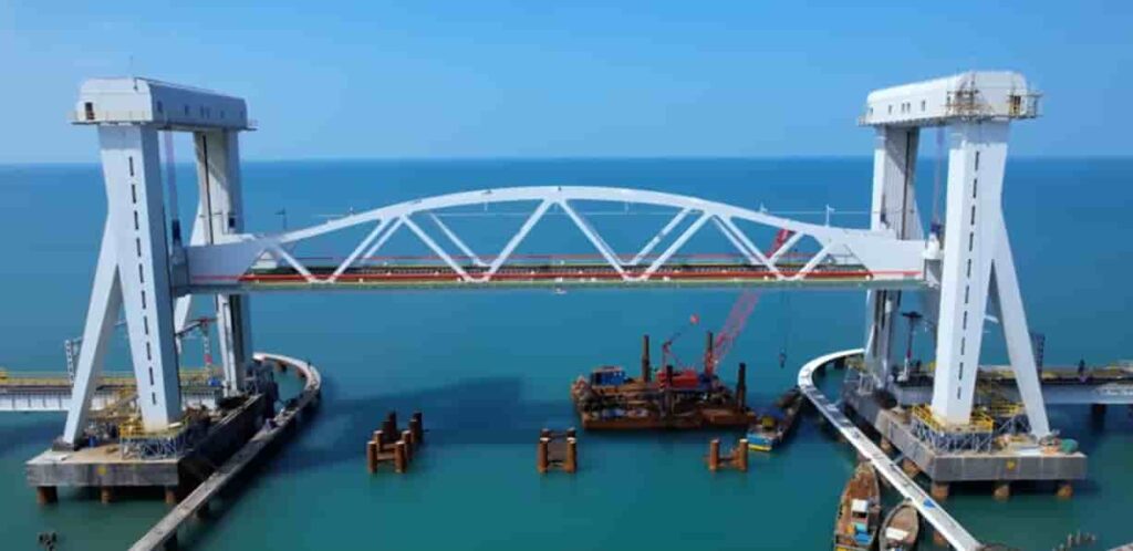
IntroductionThe New Pamban Bridge, popularly referred to as the Rameshwaram Folding Bridge, marks a major milestone in India’s railway and maritime infrastructure. Connecting mainland India to Rameswaram, the bridge has been designed as a modern replacement for the historic Pamban Bridge.What makes this project unique is its vertical lift mechanism, which allows a section of the bridge to be raised to let ships pass underneath—something never seen before in India at this scale.Background and Need for the New BridgeThe original Pamban Bridge, inaugurated in 1914, served as India’s first sea bridge and remained a crucial rail link for over a century. However, due to aging infrastructure, increasing maintenance challenges, and the need for faster and safer train movement, the necessity for a modern replacement became evident.The new bridge was conceptualised to:Enhance safety and durabilitySupport higher train speedsImprove maritime navigationThis led to the development of the New Pamban Bridge, incorporating advanced engineering and modern design.Key Features of the Rameshwaram Folding BridgeVertical Lift MechanismThe most striking feature of the bridge is its 72.5-metre-long vertical lift span. Unlike the old bridge, which had a manually operated opening system, the new structure uses an automated lift mechanism that raises the central span vertically.This allows large vessels to pass through without disrupting rail operations for extended periods.Modern Engineering and DesignThe bridge spans approximately 2.07 kilometres over the sea and has been constructed using corrosion-resistant materials to withstand harsh marine conditions.Key design elements include:Automated control systemsHigh-strength steel structureAdvanced monitoring for safetyThese features ensure long-term durability and reduced maintenance requirements.Improved Rail ConnectivityThe new bridge supports faster train speeds compared to the old Pamban Bridge, significantly improving connectivity between mainland Tamil Nadu and Rameswaram.This is particularly important given Rameswaram’s status as a major religious and tourist destination.Strategic and Cultural ImportanceRameswaram holds immense religious significance as it is home to the Ramanathaswamy Temple, one of the holiest pilgrimage sites in India.The improved rail connectivity provided by the new bridge is expected to:Facilitate smoother travel for pilgrimsBoost tourism in the regionStrengthen local economic activityThe bridge thus plays a vital role not just in infrastructure but also in preserving cultural and religious connectivity.Construction and ChallengesBuilding a sea bridge with a vertical lift mechanism presented several challenges:Working in a high-salinity marine environmentEnsuring structural stability against strong winds and tidesIntegrating advanced mechanical systems for the lift spanEngineers had to adopt specialised construction techniques and materials to ensure the bridge could withstand these conditions over time.Comparison with the Old Pamban BridgeWhile the old Pamban Bridge was a marvel of its time, the new bridge represents a significant technological upgrade.FeatureOld Pamban BridgeNew Folding BridgeOpening MechanismManualAutomated vertical liftSpeed CapacityLimitedHigher train speedsMaintenanceHighReduced due to modern materialsDurabilityAging structureDesigned for long-term useThis transition highlights India’s progress in adopting modern engineering solutions.Economic and Regional ImpactThe Rameshwaram Folding Bridge is expected to contribute significantly to regional development.Boost to TourismWith improved connectivity, more tourists and pilgrims are expected to visit Rameswaram, benefiting local businesses and hospitality sectors.Enhanced Trade and MobilityThe bridge ensures uninterrupted rail connectivity, supporting the movement of goods and people more efficiently.Environmental ConsiderationsGiven its location in a sensitive marine ecosystem, the project incorporated measures to minimise environmental impact. Efforts were made to:Reduce disturbance to marine lifeEnsure sustainable construction practicesMonitor ecological balance during and after constructionFinal PerspectiveThe Rameshwaram Folding Bridge, or New Pamban Bridge, stands as a symbol of India’s engineering advancement and its commitment to modernising critical infrastructure. By combining innovative design with strategic importance, the bridge not only enhances connectivity but also preserves a vital cultural link to one of the country’s most significant pilgrimage destinations.It represents the seamless blending of tradition and technology—honouring the legacy of the old bridge while paving the way for a more efficient and resilient future.
Atal Setu: India’s Longest Sea Bridge Transforming Mumbai’s Connectivity
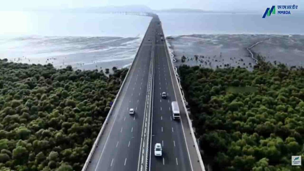
IntroductionThe Atal Setu, officially known as the Mumbai Trans Harbour Link, is one of India’s most remarkable infrastructure achievements. Connecting Mumbai with Navi Mumbai, this sea bridge has significantly transformed travel across the Mumbai Metropolitan Region.Inaugurated in January 2024, the project stands as India’s longest sea bridge and represents a major milestone in enhancing urban mobility, reducing congestion, and supporting economic growth in one of the country’s busiest regions.Project OverviewThe Atal Setu stretches approximately 21.8 kilometres, of which around 16.5 kilometres lies over the Arabian Sea. Developed by the Mumbai Metropolitan Region Development Authority, the bridge connects Sewri in Mumbai to Nhava Sheva in Navi Mumbai.Designed as a six-lane access-controlled expressway, the bridge allows high-speed travel and provides a direct link between South Mumbai and key areas such as:Navi MumbaiJawaharlal Nehru Port TrustNavi Mumbai International Airport (upcoming)This strategic alignment makes the bridge a critical infrastructure asset for both passenger and cargo movement.Need and Strategic ImportanceBefore the construction of Atal Setu, connectivity between Mumbai and Navi Mumbai relied heavily on longer routes via Thane or Vashi, often leading to heavy congestion and extended travel times.The bridge was conceptualised to:Provide a faster alternative routeReduce traffic burden on existing corridorsImprove connectivity to ports and upcoming infrastructure projectsIt is expected to reduce travel time between Sewri and Nhava Sheva from nearly two hours during peak traffic to about 20 minutes.Engineering Excellence and DesignSpecial materials and coatings were used to ensure durability and long-term performance.Intelligent Transport SystemsThe bridge is equipped with modern traffic management systems, including:Speed monitoring camerasEmergency response systemsSurveillance infrastructureThese features enhance safety and ensure smooth traffic flow.Safety RestrictionsTo maintain safety, certain categories of vehicles such as two-wheelers, auto-rickshaws, and tractors are restricted from using the bridge.Economic and Urban ImpactThe Atal Setu is expected to play a transformative role in the economic and urban development of the Mumbai Metropolitan Region.Boost to Logistics and TradeWith improved access to Jawaharlal Nehru Port Trust, India’s largest container port, the bridge enhances the efficiency of cargo transportation and logistics operations.Real Estate and Urban ExpansionThe project is expected to accelerate development in Navi Mumbai, making it a more attractive destination for residential and commercial investment.Airport ConnectivityThe bridge provides seamless access to the upcoming Navi Mumbai International Airport, strengthening regional connectivity.The Atal Setu is a testament to advanced engineering and modern construction techniques.Sea Bridge ConstructionBuilding a long bridge over open sea posed several challenges, including:Strong tidal currentsCorrosion due to saline conditionsEnvironmental constraintsEnvironmental ConsiderationsGiven its location over the sea, the project required careful environmental planning.Measures included:Minimising impact on marine ecosystemsMonitoring coastal biodiversityAdhering to environmental regulationsDespite these efforts, environmental concerns were raised during the planning and construction phases, particularly regarding potential effects on marine life.Challenges During ConstructionThe construction of Atal Setu involved multiple challenges:Working in deep-sea conditionsManaging logistics for large-scale constructionEnsuring minimal disruption to shipping routesDelays due to environmental clearances and pandemic-related disruptionsDespite these obstacles, the project was completed through coordinated efforts and advanced engineering solutions.Integration with Other Infrastructure ProjectsThe Atal Setu is part of a broader infrastructure network aimed at improving connectivity in the Mumbai region. It complements:Mumbai Coastal Road ProjectNavi Mumbai International AirportExisting highway and rail networksThis integrated approach enhances overall transport efficiency and supports regional growth.Final PerspectiveThe Atal Setu stands as a landmark achievement in India’s infrastructure development, symbolising innovation, scale, and ambition. By drastically reducing travel time and improving connectivity between Mumbai and Navi Mumbai, it has reshaped commuting patterns and opened new avenues for economic expansion.More than just a bridge, Atal Setu represents a critical link in India’s journey towards building world-class infrastructure that supports both urban growth and national development.
Noida International Airport (Jewar Airport) Inauguration: A Transformational Push to India’s Aviation and Regional Growth
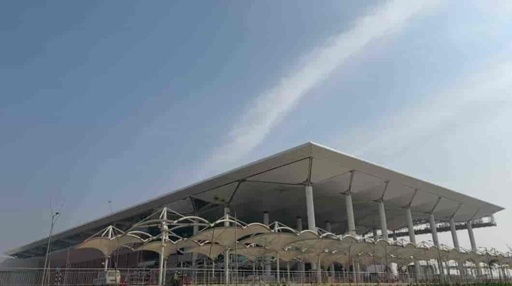
The inauguration of the Noida International Airport, widely known as Jewar Airport, marked a landmark moment in India’s aviation and infrastructure expansion. Positioned as one of the country’s largest and most ambitious greenfield airport projects, its launch has been seen as a strategic move to decongest existing aviation hubs and unlock new economic potential across northern India.Located in Jewar in Uttar Pradesh’s Gautam Buddha Nagar district, the airport has been developed to serve the rapidly growing travel demand of the National Capital Region (NCR), while also acting as a catalyst for industrial, logistical, and urban development in surrounding areas.Why India Needed a Second Major Airport in NCRFor years, the Indira Gandhi International Airport in Delhi has handled the bulk of air traffic in northern India. With passenger numbers steadily rising, the airport has been operating close to its maximum capacity, leading to congestion, delays, and operational strain.The idea of developing a second airport in the NCR was not just about expansion, but about redistributing aviation load and future-proofing infrastructure. The Noida International Airport was conceptualised to address these issues while supporting the long-term growth of one of India’s busiest urban corridors.Its location near the Yamuna Expressway provides strategic access not only to Delhi but also to key cities like Noida, Greater Noida, Ghaziabad, Agra, Mathura, and Aligarh. This makes it a regional hub rather than just an alternative airport.Scale, Design and Multi-Phase DevelopmentWhat sets the Noida International Airport apart is its scale and long-term vision. Unlike many existing airports that evolved through gradual expansion, this project has been planned from the outset as a multi-phase mega infrastructure development.In its first phase, the airport has been designed to handle around 12 million passengers annually, with a single runway and terminal. However, the long-term plan is far more ambitious. Once fully developed, the airport is expected to:Handle over 70 million passengers per yearOperate multiple runwaysInclude expansive cargo terminals and logistics parksSupport maintenance, repair, and overhaul (MRO) operationsThis phased approach ensures that the airport can scale alongside demand, making it a future-ready aviation hub.Focus on Sustainability and Modern InfrastructureOne of the defining aspects of the project is its emphasis on sustainability. The airport has been planned as an environmentally responsible infrastructure project, incorporating:Energy-efficient terminal designsWater conservation systemsReduced carbon footprint strategiesSustainable construction practicesGlobally, there has been increasing focus on green aviation infrastructure, and the Noida International Airport aligns with this shift by aiming to become one of the more eco-conscious airports in the region.Connectivity and Integration with Transport NetworksA major strength of the Jewar airport lies in its planned connectivity. The project is not being developed in isolation but as part of a larger, integrated transport ecosystem.The airport is expected to be connected through:The Yamuna Expressway and Eastern Peripheral ExpresswayProposed metro rail extensionsRegional Rapid Transit Systems (RRTS)High-speed rail links in the futureThis multi-modal integration will ensure seamless movement of passengers and goods, significantly reducing travel time and improving accessibility across the NCR and beyond.Economic Impact: A New Growth Engine for Uttar PradeshThe inauguration of the airport is expected to trigger a wave of economic activity in the region. Large infrastructure projects often act as growth multipliers, and Jewar is already witnessing rapid transformation.The airport is likely to:Generate thousands of direct and indirect employment opportunitiesBoost real estate demand in nearby areasAttract domestic and international investmentPromote development of logistics and warehousing hubsPlans for an aerotropolis—a city built around the airport—are also underway, which could include business districts, commercial centres, hotels, and industrial zones.This development is expected to strengthen Uttar Pradesh’s position as a major economic and industrial hub in northern India.Boost to Trade, Cargo and LogisticsBeyond passenger travel, the airport is expected to play a crucial role in cargo and logistics operations. With increasing demand for faster supply chains and export-oriented industries, the need for efficient cargo infrastructure has grown significantly.The Noida International Airport is being developed with dedicated cargo facilities, which will:Facilitate faster movement of goodsSupport export industries in the regionImprove connectivity for perishable and high-value goodsIts proximity to industrial clusters makes it particularly well-suited to serve as a logistics hub.Impact on Travel and Passenger ExperienceFor travellers, the airport is expected to bring noticeable improvements in convenience and efficiency. With reduced pressure on Delhi’s main airport, passengers can expect:Shorter wait timesBetter flight availabilityImproved travel experienceResidents of Noida, Greater Noida, and nearby regions will especially benefit, as they will no longer need to rely solely on Delhi for international travel.A Shift Towards Decentralised Urban DevelopmentThe development of the Jewar airport reflects a broader shift in India’s urban planning strategy—moving away from over-centralisation towards distributed growth models.By creating infrastructure hubs outside major metropolitan centres, the government aims to:Reduce pressure on existing citiesEncourage balanced regional developmentImprove quality of life in emerging urban zonesThe airport is expected to play a key role in shaping the future growth of the NCR, particularly in the Noida-Greater Noida belt.A Defining Moment in India’s Infrastructure StoryThe inauguration of the Noida International Airport is not just about adding another airport to the country’s aviation network. It represents a long-term vision for connectivity, economic expansion, and urban transformation.As air travel continues to grow in India, projects like Jewar airport will play a crucial role in ensuring that infrastructure keeps pace with demand. With its scale, strategic location, and integrated planning, the airport is poised to become one of the most important aviation hubs in the country in the coming years.In many ways, it signals how India is preparing for the next phase of growth—by investing in infrastructure that is not only large in scale but also forward-looking in design and impact.
Sonamarg Tunnel: A Key Milestone in Jammu and Kashmir’s All-Weather Connectivity
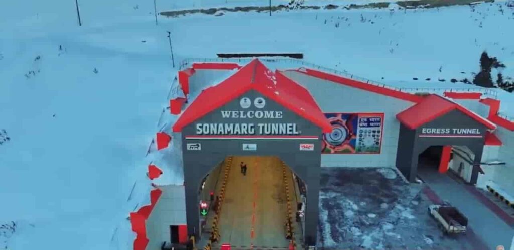
The Sonamarg Tunnel, officially known as the Z-Morh Tunnel, marked a significant step in improving infrastructure in Jammu and Kashmir. Built along the strategic Srinagar–Leh highway, the tunnel has addressed one of the region’s long-standing challenges—seasonal isolation of Sonamarg due to extreme weather conditions.For decades, Sonamarg remained cut off during winters as heavy snowfall and avalanches made the route unsafe and often impassable. The opening of this tunnel has fundamentally changed that reality, ensuring smoother, safer, and uninterrupted connectivity.Overcoming a Long-Standing Connectivity ChallengeLocated between Gagangir and Sonamarg, the tunnel bypasses a particularly vulnerable stretch of road that was notorious for landslides, avalanches, and sharp turns. This stretch, often referred to as the “Z-Morh” due to its winding shape, posed serious risks to travellers and frequently led to prolonged road closures.With the tunnel now operational, the dependency on weather conditions has been significantly reduced. What was once a seasonal route has now been transformed into an all-weather corridor, ensuring that Sonamarg remains accessible throughout the year.Engineering in Extreme TerrainConstructing the tunnel in the Himalayan region was a complex and demanding task. The area is characterised by fragile geology, sub-zero temperatures, and unpredictable weather patterns, all of which posed challenges during construction.The tunnel stretches approximately 6.5 kilometres and has been designed as a modern, two-lane passage capable of handling bi-directional traffic efficiently. Advanced tunnelling techniques were used to cut through the mountainous terrain, while maintaining structural stability and safety.In addition to the main tunnel, extensive work was carried out on approach roads and protective structures to safeguard the route from avalanches and falling debris.Safety and Modern InfrastructureThe Sonamarg Tunnel has been equipped with several modern safety systems to ensure a secure travel experience. Continuous ventilation ensures air quality inside the tunnel, while surveillance systems allow real-time monitoring of traffic movement.Emergency response mechanisms, including escape routes and communication systems, have been integrated into the design. These features are particularly important given the tunnel’s location in a remote and high-altitude region, where immediate external assistance may not always be available.Boost to Tourism and Local EconomyOne of the most immediate impacts of the tunnel has been on tourism. Sonamarg, often called the “Meadow of Gold,” is one of the most scenic destinations in Jammu and Kashmir, but its accessibility was limited to a few months each year.With year-round connectivity now possible, the region is expected to witness a steady increase in tourist inflow. This will directly benefit local businesses, including hotels, transport operators, and small vendors who rely heavily on seasonal tourism.The tunnel has also improved the movement of goods and services, contributing to better economic stability for local communities.Strategic Importance and Connectivity to LadakhBeyond tourism, the tunnel plays a crucial role in enhancing connectivity towards Ladakh. The Srinagar–Leh highway is of significant strategic importance, particularly for defence movement and logistics.By ensuring smoother and more reliable access along this route, the Sonamarg Tunnel strengthens both civilian and strategic mobility in the region. It also complements larger infrastructure projects such as the Zojila Tunnel, which aims to further enhance all-weather connectivity between Srinagar and Leh.Transforming Travel in the RegionThe experience of travelling to Sonamarg has changed considerably with the opening of the tunnel. Journeys that were once uncertain and weather-dependent have become more predictable and safer.Reduced travel time, improved road safety, and uninterrupted access have collectively enhanced the overall connectivity of the region. This shift is expected to play a long-term role in integrating remote areas with mainstream economic and social networks.The Sonamarg Tunnel stands as a testament to India’s growing capability in executing complex infrastructure projects in challenging terrains. By addressing both connectivity and safety concerns, it has not only improved access to a key tourist destination but also contributed to the broader goal of regional development in Jammu and Kashmir.