

PM Modi Inaugurates Micron’s Semiconductor ATMP Facility in Sanand
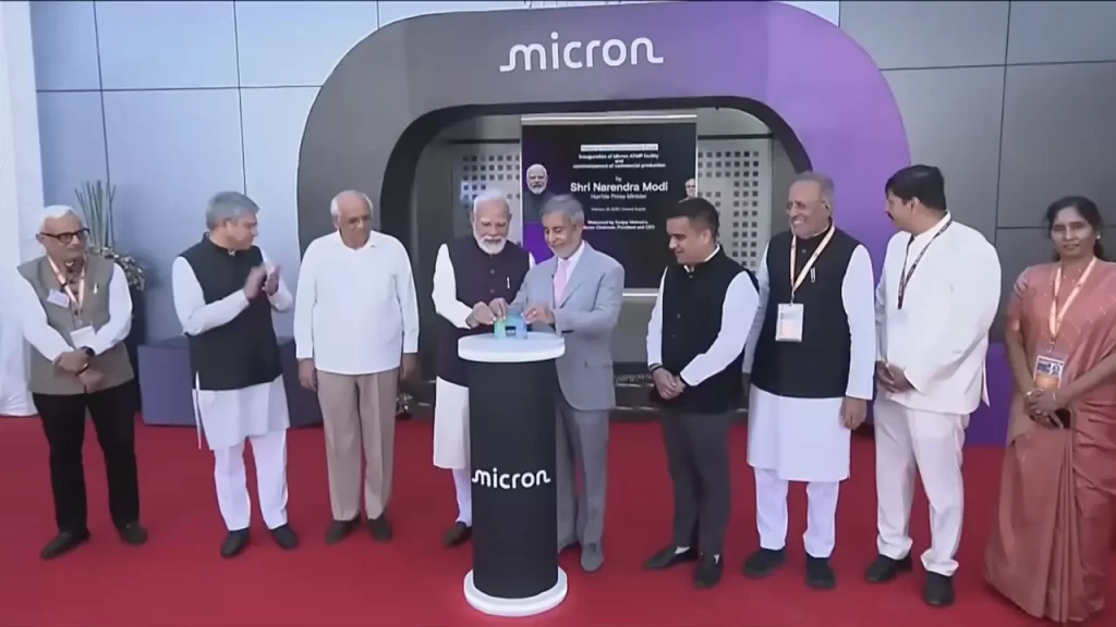
Prime Minister Narendra Modi inaugurated Micron Technology’s state-of-the-art Semiconductor Assembly, Test, and Packaging (ATMP) facility in Sanand, Gujarat, on February 28, 2026, marking India’s entry into commercial semiconductor production. This $2.75 billion milestone, the first of its kind in the country, converts advanced DRAM and NAND wafers into finished memory products for AI, data centers, and mobiles, positioning India as a key player in the global chip value chain.From MoU to Production: Lightning-Fast ExecutionThe project’s speed exemplifies India’s “New India” mindset. Signed in June 2023, groundbreaking occurred in September 2023, pilot machines installed by February 2024, and commercial production began in February 2026, just 33 months end-to-end. PM Modi highlighted streamlined regulations, like Advanced Pricing Agreements (APAs) cleared in months versus 3-5 years elsewhere, crediting clear intent and nation-first dedication.The Sanand plant boasts over 500,000 sq ft of cleanroom, one of the world’s largest single-floor ATMP cleanrooms, ISO 9001:2015 certified, LEED Gold-bound, and zero-liquid discharge via water-saving tech. First made-in-India memory modules shipped to Dell for local laptops, with tens of millions of chips expected in 2026, scaling to hundreds of millions in 2027.Micron CEO Sanjay Mehrotra, at the event with Gujarat CM Bhupendra Patel, Union Minister Ashwini Vaishnaw, and US Ambassador Sergio Gor, called it a “proud moment” building resilient AI ecosystems. Vaishnaw termed it “historic,” shifting India from chip consumer to manufacturing hub under PM Modi’s leadership.Microchips: The Oil of the 21st CenturyPM Modi framed semiconductors as the bridge from the Industrial Revolution to the AI era: “If oil regulated the last century, microchips will regulate this one.” Launched amid COVID chaos via the Semiconductor Mission, early seeds now yield fruit. India approved 10 projects under Semicon India; three more ramp up soon in Uttar Pradesh, Assam, Odisha, and Punjab, creating a pan-India ecosystem beyond factories, encompassing machines, design, R&D, logistics, and skills.Budget 2026’s India Semiconductor Mission 2.0 targets the full value chain, spurring domestic demand for materials amid booming gadget adoption. Electronics production and exports surged manifold in 11 years; “Make in India” now powers automobiles, mobiles, and tech.Sanand mirrors its auto-hub transformation, now anchoring semiconductors alongside chemicals, petrochemicals, and skill centers. Gujarat’s policies on approvals, land, and utilities boost investor faith; Dholera and Sanand emerge as Western India’s chip clusters.India-US Partnership Powers Global Supply ResilienceThe facility underscores deepening India-US ties in AI and chips, including the Pax Silica agreement from the recent AI Summit for critical minerals. The two largest democracies secure supply chains amid geopolitical flux. PM Modi messaged investors: “India is ready, reliable, delivers, capable, competitive, committed.”Micron’s Gujarat push builds talent via PDEU, Namtech, nationwide universities, and govt skills programs, focusing on STEM, advanced manufacturing, digital/AI literacy. Sustainability integrates health, safety, and eco-commitments.Broader Semiconductor Ecosystem BoomThis ATMP unit complements fabs like Tata’s in Dholera and others, addressing AI-driven memory demand. India’s electronics journey, from IT services to hardware, accelerates Viksit Bharat. Key Project MetricsDetailsKey Project MetricsDetailsInvestment$2.75B (Micron + govt)Cleanroom Size500,000+ sq ft (world’s largest single-floor ATMP)Output 2026Tens of millions of chipsOutput 2027Hundreds of millionsTimelineMoU Jun’23 → Production Feb’26States InvolvedGujarat, UP, Assam, Odisha, PunjabGlobal PartnersUS (Micron, Dell), via Pax SilicaA Tech Leadership LeapFrom software superpower to hardware contender, the nation builds self-reliant ecosystems fueling AI, mobiles, EVs. As PM Modi envisioned post-AI Summit, this hardware milestone cements technology leadership, inviting the world to co-create in a reliable, scalable hub.
Vadhavan Port: India’s Next Mega Deep-Sea Gateway
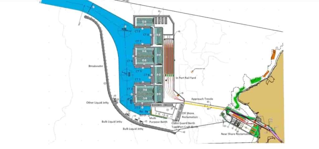
IntroductionThe Vadhavan Port Project is one of the most ambitious port development initiatives currently underway in the country. Planned along the western coastline near Dahanu, the project is being positioned as a world-class deep-sea port that will significantly enhance India’s maritime capacity and global trade competitiveness.At a time when India is aiming to become a major player in global supply chains, Vadhavan Port is expected to play a transformative role by handling ultra-large cargo vessels and reducing dependence on foreign transshipment hubs.Background and Strategic NeedIndia’s growing economy and increasing trade volumes have highlighted the limitations of existing ports, particularly in handling large container ships. A significant portion of India’s cargo is still transshipped through ports in countries like Singapore and Sri Lanka.The Vadhavan Port Project was conceptualised to address these gaps by creating a deep-draft port capable of accommodating next-generation container vessels. Its development aligns with national initiatives such as the Sagarmala Programme, which focuses on port-led development.Location and Project LayoutThe port is being developed near Dahanu in Maharashtra, strategically located along the Arabian Sea and close to major industrial and commercial hubs like Mumbai and Gujarat.The project is being executed by Jawaharlal Nehru Port Authority (JNPA), which already operates India’s largest container port at Nhava Sheva.Key aspects of the project include:Development of deep-draft berthsLarge-scale land reclamationModern cargo handling infrastructureRail and road connectivity to hinterland regionsKey Features and CapacityDeep-Sea CapabilityOne of the defining features of Vadhavan Port is its natural deep draft, which allows it to handle ultra-large container vessels (ULCVs) with capacities exceeding 20,000 TEUs. This will place the port among the most advanced in the world.Massive Cargo Handling CapacityOnce completed, the port is expected to have a capacity of over 200 million tonnes per annum, making it one of India’s largest ports.Advanced InfrastructureThe port will be equipped with:Automated cargo handling systemsSmart logistics and digital trackingDedicated freight corridorsThese features aim to ensure efficiency, speed, and global competitiveness.Economic SignificanceThe Vadhavan Port Project is expected to have far-reaching economic implications.Reduction in Logistics CostsBy enabling direct handling of large vessels, the port will reduce the need for transshipment through foreign ports, lowering logistics costs and saving time.Boost to Exports and TradeImproved port capacity and efficiency will strengthen India’s export capabilities and integration into global trade networks.Employment and Industrial GrowthThe project is expected to generate significant employment opportunities during both construction and operational phases. It will also promote industrial development in surrounding regions.Connectivity and IntegrationThe port is being designed with strong connectivity to major transport networks, including:National highwaysRailway freight corridorsIndustrial clustersThis integrated approach ensures seamless movement of goods from ports to inland markets.Environmental Concerns and OppositionDespite its economic potential, the project has faced strong opposition from environmental groups and local communities.Ecological ImpactConcerns have been raised about:Impact on marine biodiversityDamage to coastal ecosystemsEffects on fishing communitiesDahanu is considered an ecologically sensitive zone, which has intensified debates around the project.Legal and Regulatory ChallengesThe project has undergone extensive environmental scrutiny and regulatory processes. Balancing development with environmental sustainability remains a key challenge.Progress and Current StatusAs of 2026, the Vadhavan Port Project has received key approvals and is moving through various stages of planning and early development. Land acquisition, environmental clearances, and infrastructure planning are ongoing.The project is expected to be developed in phases over the coming years.Strategic Importance for IndiaVadhavan Port is not just another infrastructure project—it is a strategic initiative aimed at positioning India as a major maritime and logistics hub.By reducing dependence on foreign ports and enhancing domestic capacity, the project strengthens India’s economic sovereignty in global trade.It also complements other major infrastructure initiatives, including port modernisation and logistics reforms under national programmes.Final PerspectiveThe Vadhavan Port Project represents India’s long-term vision of building world-class maritime infrastructure capable of competing on a global scale. While it promises significant economic and strategic benefits, it also highlights the complexities of developing large-scale projects in environmentally sensitive regions.As the project progresses, its success will depend on how effectively it balances growth, sustainability, and the interests of local communities—making it one of the most closely watched infrastructure developments in the country.
Rameshwaram Folding Bridge: India’s First Vertical Lift Sea Bridge
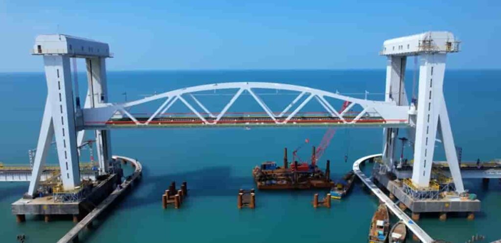
IntroductionThe New Pamban Bridge, popularly referred to as the Rameshwaram Folding Bridge, marks a major milestone in India’s railway and maritime infrastructure. Connecting mainland India to Rameswaram, the bridge has been designed as a modern replacement for the historic Pamban Bridge.What makes this project unique is its vertical lift mechanism, which allows a section of the bridge to be raised to let ships pass underneath—something never seen before in India at this scale.Background and Need for the New BridgeThe original Pamban Bridge, inaugurated in 1914, served as India’s first sea bridge and remained a crucial rail link for over a century. However, due to aging infrastructure, increasing maintenance challenges, and the need for faster and safer train movement, the necessity for a modern replacement became evident.The new bridge was conceptualised to:Enhance safety and durabilitySupport higher train speedsImprove maritime navigationThis led to the development of the New Pamban Bridge, incorporating advanced engineering and modern design.Key Features of the Rameshwaram Folding BridgeVertical Lift MechanismThe most striking feature of the bridge is its 72.5-metre-long vertical lift span. Unlike the old bridge, which had a manually operated opening system, the new structure uses an automated lift mechanism that raises the central span vertically.This allows large vessels to pass through without disrupting rail operations for extended periods.Modern Engineering and DesignThe bridge spans approximately 2.07 kilometres over the sea and has been constructed using corrosion-resistant materials to withstand harsh marine conditions.Key design elements include:Automated control systemsHigh-strength steel structureAdvanced monitoring for safetyThese features ensure long-term durability and reduced maintenance requirements.Improved Rail ConnectivityThe new bridge supports faster train speeds compared to the old Pamban Bridge, significantly improving connectivity between mainland Tamil Nadu and Rameswaram.This is particularly important given Rameswaram’s status as a major religious and tourist destination.Strategic and Cultural ImportanceRameswaram holds immense religious significance as it is home to the Ramanathaswamy Temple, one of the holiest pilgrimage sites in India.The improved rail connectivity provided by the new bridge is expected to:Facilitate smoother travel for pilgrimsBoost tourism in the regionStrengthen local economic activityThe bridge thus plays a vital role not just in infrastructure but also in preserving cultural and religious connectivity.Construction and ChallengesBuilding a sea bridge with a vertical lift mechanism presented several challenges:Working in a high-salinity marine environmentEnsuring structural stability against strong winds and tidesIntegrating advanced mechanical systems for the lift spanEngineers had to adopt specialised construction techniques and materials to ensure the bridge could withstand these conditions over time.Comparison with the Old Pamban BridgeWhile the old Pamban Bridge was a marvel of its time, the new bridge represents a significant technological upgrade.FeatureOld Pamban BridgeNew Folding BridgeOpening MechanismManualAutomated vertical liftSpeed CapacityLimitedHigher train speedsMaintenanceHighReduced due to modern materialsDurabilityAging structureDesigned for long-term useThis transition highlights India’s progress in adopting modern engineering solutions.Economic and Regional ImpactThe Rameshwaram Folding Bridge is expected to contribute significantly to regional development.Boost to TourismWith improved connectivity, more tourists and pilgrims are expected to visit Rameswaram, benefiting local businesses and hospitality sectors.Enhanced Trade and MobilityThe bridge ensures uninterrupted rail connectivity, supporting the movement of goods and people more efficiently.Environmental ConsiderationsGiven its location in a sensitive marine ecosystem, the project incorporated measures to minimise environmental impact. Efforts were made to:Reduce disturbance to marine lifeEnsure sustainable construction practicesMonitor ecological balance during and after constructionFinal PerspectiveThe Rameshwaram Folding Bridge, or New Pamban Bridge, stands as a symbol of India’s engineering advancement and its commitment to modernising critical infrastructure. By combining innovative design with strategic importance, the bridge not only enhances connectivity but also preserves a vital cultural link to one of the country’s most significant pilgrimage destinations.It represents the seamless blending of tradition and technology—honouring the legacy of the old bridge while paving the way for a more efficient and resilient future.
Atal Setu: India’s Longest Sea Bridge Transforming Mumbai’s Connectivity
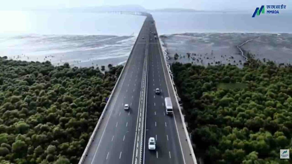
IntroductionThe Atal Setu, officially known as the Mumbai Trans Harbour Link, is one of India’s most remarkable infrastructure achievements. Connecting Mumbai with Navi Mumbai, this sea bridge has significantly transformed travel across the Mumbai Metropolitan Region.Inaugurated in January 2024, the project stands as India’s longest sea bridge and represents a major milestone in enhancing urban mobility, reducing congestion, and supporting economic growth in one of the country’s busiest regions.Project OverviewThe Atal Setu stretches approximately 21.8 kilometres, of which around 16.5 kilometres lies over the Arabian Sea. Developed by the Mumbai Metropolitan Region Development Authority, the bridge connects Sewri in Mumbai to Nhava Sheva in Navi Mumbai.Designed as a six-lane access-controlled expressway, the bridge allows high-speed travel and provides a direct link between South Mumbai and key areas such as:Navi MumbaiJawaharlal Nehru Port TrustNavi Mumbai International Airport (upcoming)This strategic alignment makes the bridge a critical infrastructure asset for both passenger and cargo movement.Need and Strategic ImportanceBefore the construction of Atal Setu, connectivity between Mumbai and Navi Mumbai relied heavily on longer routes via Thane or Vashi, often leading to heavy congestion and extended travel times.The bridge was conceptualised to:Provide a faster alternative routeReduce traffic burden on existing corridorsImprove connectivity to ports and upcoming infrastructure projectsIt is expected to reduce travel time between Sewri and Nhava Sheva from nearly two hours during peak traffic to about 20 minutes.Engineering Excellence and DesignSpecial materials and coatings were used to ensure durability and long-term performance.Intelligent Transport SystemsThe bridge is equipped with modern traffic management systems, including:Speed monitoring camerasEmergency response systemsSurveillance infrastructureThese features enhance safety and ensure smooth traffic flow.Safety RestrictionsTo maintain safety, certain categories of vehicles such as two-wheelers, auto-rickshaws, and tractors are restricted from using the bridge.Economic and Urban ImpactThe Atal Setu is expected to play a transformative role in the economic and urban development of the Mumbai Metropolitan Region.Boost to Logistics and TradeWith improved access to Jawaharlal Nehru Port Trust, India’s largest container port, the bridge enhances the efficiency of cargo transportation and logistics operations.Real Estate and Urban ExpansionThe project is expected to accelerate development in Navi Mumbai, making it a more attractive destination for residential and commercial investment.Airport ConnectivityThe bridge provides seamless access to the upcoming Navi Mumbai International Airport, strengthening regional connectivity.The Atal Setu is a testament to advanced engineering and modern construction techniques.Sea Bridge ConstructionBuilding a long bridge over open sea posed several challenges, including:Strong tidal currentsCorrosion due to saline conditionsEnvironmental constraintsEnvironmental ConsiderationsGiven its location over the sea, the project required careful environmental planning.Measures included:Minimising impact on marine ecosystemsMonitoring coastal biodiversityAdhering to environmental regulationsDespite these efforts, environmental concerns were raised during the planning and construction phases, particularly regarding potential effects on marine life.Challenges During ConstructionThe construction of Atal Setu involved multiple challenges:Working in deep-sea conditionsManaging logistics for large-scale constructionEnsuring minimal disruption to shipping routesDelays due to environmental clearances and pandemic-related disruptionsDespite these obstacles, the project was completed through coordinated efforts and advanced engineering solutions.Integration with Other Infrastructure ProjectsThe Atal Setu is part of a broader infrastructure network aimed at improving connectivity in the Mumbai region. It complements:Mumbai Coastal Road ProjectNavi Mumbai International AirportExisting highway and rail networksThis integrated approach enhances overall transport efficiency and supports regional growth.Final PerspectiveThe Atal Setu stands as a landmark achievement in India’s infrastructure development, symbolising innovation, scale, and ambition. By drastically reducing travel time and improving connectivity between Mumbai and Navi Mumbai, it has reshaped commuting patterns and opened new avenues for economic expansion.More than just a bridge, Atal Setu represents a critical link in India’s journey towards building world-class infrastructure that supports both urban growth and national development.
PM Modi’s Mann Ki Baat E-133 | 26th April, 2026

PM Modi’s Mann Ki Baat E-133 | 26th April, 2026 Video: YT/@NaMo
Samruddhi Mahamarg: Maharashtra’s High-Speed Economic Corridor
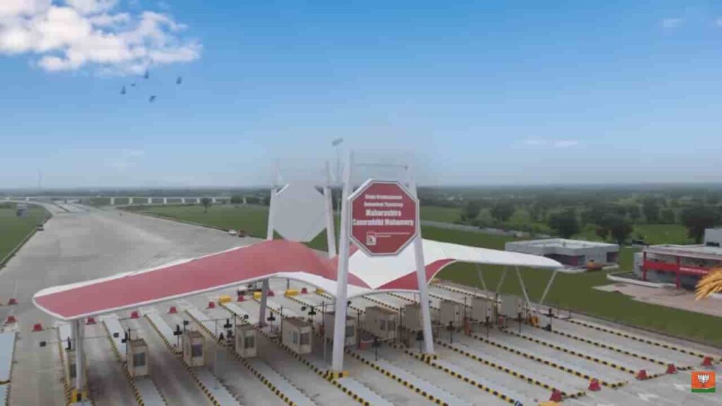
IntroductionThe Hindu Hrudaysamrat Balasaheb Thackeray Maharashtra Samruddhi Mahamarg, commonly known as the Samruddhi Mahamarg, is one of India’s most ambitious expressway projects aimed at transforming connectivity and economic development across Maharashtra. Designed as a high-speed, access-controlled corridor, the expressway connects the state capital Mumbai with Nagpur, significantly reducing travel time and boosting regional growth.The project represents a major step in strengthening infrastructure while promoting balanced development across urban and rural regions of the state.Project Overview and RouteThe Samruddhi Mahamarg spans approximately 701 kilometres, making it one of the longest expressways in India. It passes through 10 districts and connects key regions including Nashik, Aurangabad (now Chhatrapati Sambhajinagar), and Amravati.The expressway has been developed by the Maharashtra State Road Development Corporation and is designed for high-speed vehicular movement, with a maximum speed limit of up to 120 km/h.The corridor begins near Mumbai and stretches eastward to Nagpur, creating a direct and efficient link between the two major cities.Need and Vision Behind the ProjectBefore the construction of the Samruddhi Mahamarg, travel between Mumbai and Nagpur could take up to 16–18 hours due to traffic congestion and road conditions. The need for a faster, safer, and more efficient route was critical for both passenger and freight movement.The vision behind the project goes beyond connectivity. It aims to create an “economic corridor” by:Linking underdeveloped regions with major marketsPromoting industrial and agricultural growthEncouraging investment along the routeThe expressway is expected to serve as a backbone for regional development in Maharashtra.Key Features and DesignThe Samruddhi Mahamarg incorporates modern infrastructure and safety features to ensure smooth and secure travel.Access-Controlled ExpresswayThe highway is fully access-controlled, meaning vehicles can enter and exit only at designated interchanges. This reduces traffic interruptions and enhances safety.High-Speed CorridorWith multiple lanes and a high design speed, the expressway enables faster travel compared to traditional highways.Advanced Safety MeasuresThe project includes:Wildlife crossings and underpassesEmergency response systemsSurveillance and monitoring infrastructureThese measures aim to minimise accidents and ensure passenger safety.Smart InfrastructureThe expressway is equipped with intelligent traffic management systems, making it one of the technologically advanced road projects in India.Economic Impact and Development PotentialThe Samruddhi Mahamarg is expected to have a transformative impact on Maharashtra’s economy.Boost to Trade and LogisticsBy reducing travel time and transportation costs, the expressway enhances the efficiency of goods movement across the state.Industrial GrowthThe government has planned the development of industrial hubs, logistics parks, and smart cities along the corridor. These developments are expected to attract investment and generate employment.Agricultural BenefitsFarmers in rural regions will gain better access to markets, reducing wastage and increasing income opportunities.Progress and ImplementationThe expressway has been opened in phases, with major sections becoming operational between 2022 and 2024. By 2024, the full stretch connecting Mumbai and Nagpur was largely completed and made accessible to the public.The phased approach allowed for gradual integration of the expressway into the state’s transport network while ensuring quality construction.Environmental and Social ConsiderationsGiven the scale of the project, environmental and social impacts have been closely monitored.Land AcquisitionThe project required acquisition of land across multiple districts, which involved compensation and rehabilitation of affected communities.Environmental MeasuresEfforts have been made to:Develop green belts along the expresswayProvide wildlife crossings in forest areasMinimise ecological disruptionDespite these efforts, concerns have been raised about environmental impact and land use changes.Challenges FacedThe development of the Samruddhi Mahamarg encountered several challenges:Large-scale land acquisitionCoordination across multiple districtsEnvironmental clearancesConstruction during the COVID-19 pandemicHowever, the project was completed through coordinated efforts between government agencies and contractors.Strategic ImportanceThe expressway is not just a transport project but a strategic infrastructure initiative that strengthens Maharashtra’s position as an economic powerhouse.By connecting major cities and emerging regions, it supports:Balanced regional developmentImproved connectivity to ports and industrial zonesIntegration with national highway networksFinal PerspectiveThe Samruddhi Mahamarg stands as a landmark achievement in India’s infrastructure development. By drastically reducing travel time between Mumbai and Nagpur and creating new economic opportunities along its route, the project has redefined connectivity in Maharashtra.More importantly, it reflects a broader shift towards building infrastructure that not only facilitates movement but also drives inclusive growth, linking cities, industries, and rural communities into a unified economic corridor.
Sagarmala Project: Transforming India’s Maritime Infrastructure and Coastal Economy
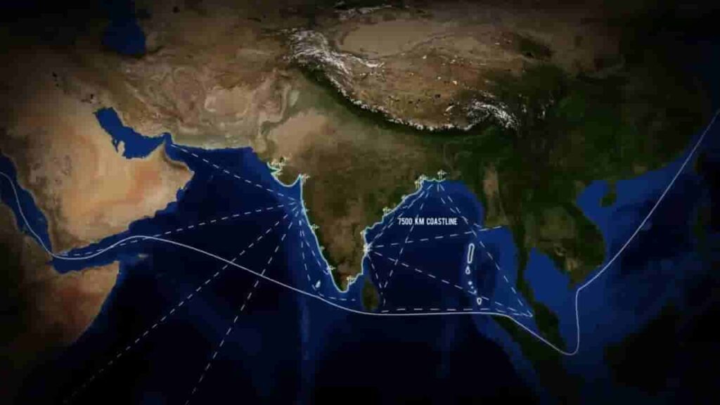
IntroductionThe Sagarmala Programme is one of the Government of India’s flagship initiatives aimed at harnessing the country’s vast coastline and maritime potential to drive economic growth. Launched with the vision of port-led development, the project seeks to modernise ports, improve logistics efficiency, and promote industrialisation along coastal regions.With over 7,500 km of coastline and strategic access to major international trade routes, India has long had the potential to become a global maritime hub. The Sagarmala Programme was designed to unlock this potential by integrating ports with hinterland connectivity and industrial development.Background and VisionIndia’s logistics sector has historically faced challenges such as high transportation costs, inefficiencies in port operations, and inadequate connectivity between ports and inland regions. Recognising these gaps, the Sagarmala Programme was introduced to create a more efficient and cost-effective logistics ecosystem.The core vision of Sagarmala is to reduce logistics costs for both domestic and international trade while boosting exports and generating employment. By focusing on port-led industrialisation, the initiative aims to transform coastal areas into economic growth centres.Key Pillars of the Sagarmala ProgrammeThe Sagarmala Project is built around four key pillars, each addressing a specific aspect of maritime and logistics development.Port Modernisation and New Port DevelopmentOne of the primary objectives is to upgrade existing ports and develop new ones to handle increasing cargo volumes. This includes improving port infrastructure, adopting advanced technologies, and enhancing operational efficiency.Major ports across India are being modernised to reduce turnaround time for ships and improve cargo handling capacity, making them globally competitive.Port Connectivity EnhancementEfficient connectivity between ports and inland regions is critical for seamless movement of goods. Under Sagarmala, significant investments have been made in road, rail, and inland waterways connectivity.Projects include:Dedicated freight corridorsRail links to portsNational highways connecting industrial clustersThese developments aim to ensure faster and more cost-effective transportation of goods.Port-Led IndustrialisationA major focus of the programme is the development of industrial clusters near ports. These include:Coastal Economic Zones (CEZs)Industrial corridorsPort-based manufacturing unitsBy locating industries closer to ports, the project reduces logistics costs and enhances export competitiveness. This approach also encourages foreign investment and boosts manufacturing under initiatives like “Make in India.”Coastal Community DevelopmentSagarmala also emphasises the socio-economic development of coastal communities. The programme includes initiatives for:Skill development in maritime sectorsEmployment generationFisheries and aquaculture developmentThis ensures that local populations benefit directly from the project’s growth opportunities.Implementation and ScaleThe Sagarmala Programme encompasses hundreds of projects across various sectors, making it one of the largest infrastructure initiatives in the country.It is being implemented by multiple agencies, including:Ministry of Ports, Shipping and WaterwaysState governmentsPrivate sector stakeholdersProjects range from port modernisation and connectivity improvements to industrial zone development and urban infrastructure in coastal regions.Economic SignificanceThe Sagarmala Project is expected to have a far-reaching impact on India’s economy.Reduction in Logistics CostsOne of the biggest advantages is the potential reduction in logistics costs, which have traditionally been higher in India compared to global standards. Efficient ports and better connectivity will make Indian goods more competitive in international markets.Boost to Trade and ExportsImproved port infrastructure and faster cargo handling will facilitate higher trade volumes, strengthening India’s position in global supply chains.Employment GenerationThe programme is expected to create millions of jobs, both directly and indirectly, across sectors such as shipping, logistics, manufacturing, and fisheries.Environmental and Social ConsiderationsGiven the scale of the project, environmental sustainability has been a key concern.Efforts have been made to:Promote green port initiativesReduce carbon emissionsEnsure sustainable coastal developmentHowever, concerns have also been raised regarding the impact of industrialisation on fragile coastal ecosystems, including mangroves and marine biodiversity.Balancing economic growth with environmental protection remains a critical challenge for the programme.Progress and AchievementsSince its launch, significant progress has been made under the Sagarmala Programme. Several port modernisation projects have been completed, and connectivity infrastructure has been strengthened.Cargo handling capacity at major ports has increased, and turnaround times have improved, reflecting enhanced efficiency. Industrial projects in coastal regions are also gradually taking shape.Challenges and the Road AheadDespite its progress, the Sagarmala Project faces several challenges:Land acquisition issuesEnvironmental clearancesCoordination between multiple agenciesFunding and timely execution of projectsAddressing these challenges will be essential to ensure the programme achieves its full potential.Final PerspectiveThe Sagarmala Programme represents a strategic shift in India’s approach to infrastructure and economic development. By leveraging its coastline and maritime strengths, the country aims to build a robust logistics network and emerge as a global trade hub.At its core, the project is not just about ports—it is about creating an integrated ecosystem that connects industries, communities, and markets, driving long-term growth and development across the nation.
Parvatmala Project: India’s National Ropeway Development Programme
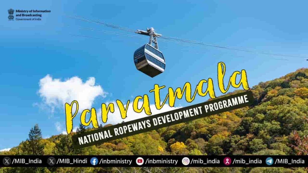
Image: MIBIntroductionThe Parvatmala Project, officially known as Parvatmala Pariyojana, was announced in the Union Budget 2022–23 as a major initiative to develop ropeway infrastructure across India, particularly in hilly and mountainous regions. The project aims to provide safe, efficient and sustainable connectivity in areas where traditional road and rail infrastructure face geographical and environmental challenges.It is being implemented under the guidance of the Ministry of Road Transport and Highways, with a strong focus on boosting connectivity, tourism, and local economic activity.Vision and ObjectivesThe core vision of the Parvatmala Project is to transform mobility in difficult terrains by introducing ropeways as a viable alternative to conventional transport systems. In many hill regions, road construction is not only expensive but also environmentally disruptive. Ropeways offer a cleaner and more efficient solution.The project is designed to:Improve last-mile connectivity in remote and hilly areasReduce travel time significantlyPromote eco-friendly transportationBoost tourism in scenic destinationsBy focusing on these objectives, the initiative seeks to integrate remote regions more effectively into the mainstream economy.Implementation StrategyThe Parvatmala Project is being developed under the Public-Private Partnership (PPP) model, which allows private players to participate in financing, constructing, and operating ropeway systems.The government has identified multiple corridors across states such as Uttarakhand, Himachal Pradesh, Jammu & Kashmir, and the Northeast for ropeway development. These routes are selected based on their tourism potential, connectivity needs, and feasibility.The project is expected to be implemented in phases, with initial priority given to high-demand routes and pilgrimage circuits.Key Features of Ropeway SystemsRopeways under the Parvatmala Project are expected to offer several advantages over traditional transport:They are designed to operate in difficult terrains with minimal land use, reducing the need for large-scale construction. Travel through ropeways is significantly faster, especially in areas where road journeys can take several hours due to winding routes.Additionally, ropeways are considered environmentally sustainable, as they produce lower emissions compared to fuel-based transport systems. They also help in reducing traffic congestion in popular tourist destinations.Economic and Tourism ImpactOne of the major expected outcomes of the Parvatmala Project is the boost to tourism. Improved connectivity to hill stations, धार्मिक sites, and remote scenic locations can increase tourist footfall and generate employment opportunities for local communities.The project is also likely to:Support small businesses in remote areasEnhance accessibility for pilgrims and touristsCreate jobs in construction, operations, and maintenanceBy improving connectivity, the initiative can play a key role in regional economic development.Challenges and ConcernsDespite its potential, the Parvatmala Project faces several challenges. Land acquisition, environmental clearances, and coordination between multiple agencies can slow down implementation.There are also concerns regarding the financial viability of certain routes, especially in areas with seasonal tourist demand. Ensuring safety standards and maintenance of ropeway systems will be critical for long-term success.The Road AheadThe government aims to develop over 200 ropeway projects covering more than 1,200 km in the coming years under the Parvatmala initiative. As implementation progresses, the focus will be on balancing infrastructure development with environmental sustainability.Successful execution of the project will depend on efficient planning, strong private sector participation, and timely clearances.ConclusionThe Parvatmala Project represents a significant shift in India’s approach to infrastructure development in mountainous regions. By introducing ropeways as a mainstream mode of transport, the initiative offers a practical solution to long-standing connectivity challenges.If implemented effectively, it has the potential to not only transform mobility in hilly areas but also drive tourism and economic growth, making remote regions more accessible and integrated with the rest of the country.
Dholera: India’s First Greenfield Smart City Taking Shape in Gujarat
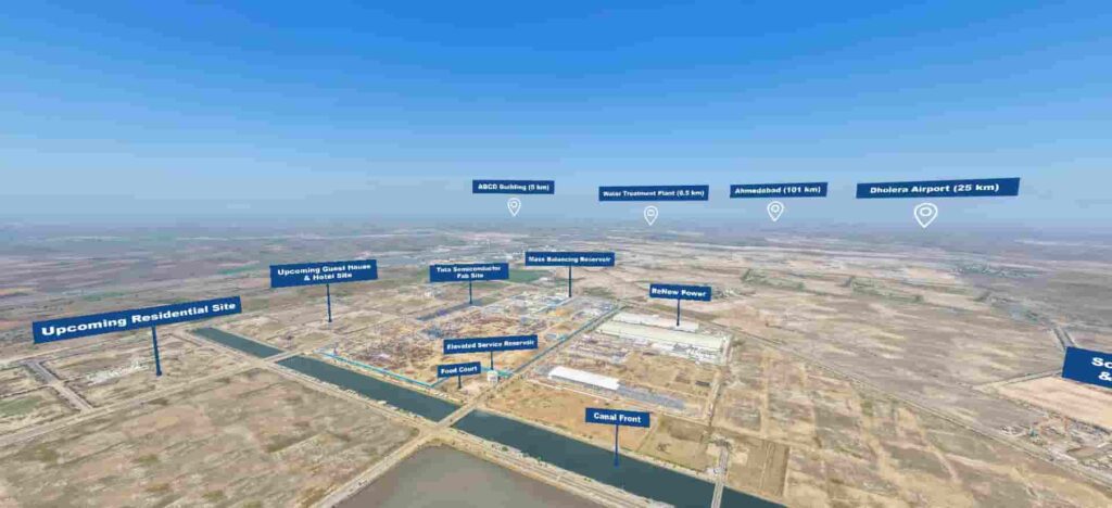
Dholera has emerged as one of India’s most ambitious urban development projects, envisioned as the country’s first greenfield smart city under the Delhi-Mumbai Industrial Corridor (DMIC). Located in Gujarat’s Ahmedabad district, Dholera is being developed from scratch with a focus on sustainable infrastructure, advanced technology, and industrial growth, positioning it as a future economic powerhouse.The project reflects India’s long-term vision of creating next-generation urban centres that can support rapid industrialisation while maintaining environmental balance and efficient governance.Vision Behind Dholera Smart CityUnlike traditional cities that evolve over time, Dholera has been planned as a greenfield city, meaning it is being built on previously undeveloped land with a fully integrated master plan.The objective behind Dholera is to:Decongest existing metropolitan citiesCreate a global manufacturing and investment hubProvide world-class infrastructure for industries and residentsDrive economic growth through planned urbanisationThe city is a key node of the Delhi Mumbai Industrial Corridor, one of India’s largest infrastructure initiatives aimed at boosting industrial development between Delhi and Mumbai.Strategic Location and ConnectivityDholera’s location gives it a strong strategic advantage. It lies around 100 kilometres from Ahmedabad and is well connected through major transport networks.The city is being linked via:The Ahmedabad-Dholera ExpresswayProposed metro rail connectivityDedicated freight corridorsProximity to ports along the western coastOne of the most important infrastructure components supporting the city is the Dholera International Airport, which is expected to enhance both domestic and international connectivity, making Dholera a globally accessible hub.Infrastructure and Smart City FeaturesDholera is being developed with a focus on future-ready infrastructure, incorporating smart technologies and sustainable systems.The city’s planning includes:Underground utility systems (electricity, water, telecom)Smart traffic management and surveillance systemsHigh-speed internet and digital connectivityIntegrated command and control centresThe infrastructure is designed to ensure efficiency, reduce congestion, and provide a high quality of life for residents and businesses.Industrial and Economic PotentialOne of the primary goals of Dholera is to function as a major industrial hub. Large tracts of land have been allocated for manufacturing, logistics, and commercial activities.The city is expected to attract:Domestic and international investorsManufacturing units across sectorsTechnology and innovation-driven industriesSpecial economic zones and industrial clusters are being planned to encourage exports and boost employment opportunities.Sustainability and Environmental PlanningA key highlight of Dholera is its focus on sustainability. The city is being designed to minimise environmental impact while supporting large-scale development.This includes:Use of renewable energy sources such as solar powerEfficient water management and recycling systemsGreen spaces and eco-friendly urban planningThe emphasis on sustainability aligns with global trends in urban development, making Dholera a model for future smart cities in India.Phased Development and Current ProgressThe development of Dholera is being carried out in phases, with initial focus on activating core infrastructure and industrial zones.The Activation Area—considered the first phase of development—has already seen progress in terms of:Road networksUtility infrastructureLand allocation for industriesAs infrastructure continues to develop, the city is gradually moving from planning to implementation, with increasing interest from investors and businesses.Challenges and ExpectationsWhile the vision for Dholera is ambitious, the project also faces challenges such as:Attracting sustained investmentEnsuring timely infrastructure developmentCreating residential demand alongside industrial growthThe success of the city will depend on how effectively these challenges are managed over time.A Glimpse into India’s Urban FutureDholera represents a shift in India’s approach to urbanisation—moving towards planned, technology-driven, and sustainable cities rather than unstructured expansion.As the project progresses, it is expected to serve as a benchmark for future smart city initiatives across the country.Dholera is not just a city under construction; it is a long-term vision of how India aims to balance growth, infrastructure, and sustainability. With its strategic location, advanced planning, and industrial focus, it has the potential to redefine urban development and emerge as a major economic hub in the years to come.
Noida International Airport (Jewar Airport) Inauguration: A Transformational Push to India’s Aviation and Regional Growth
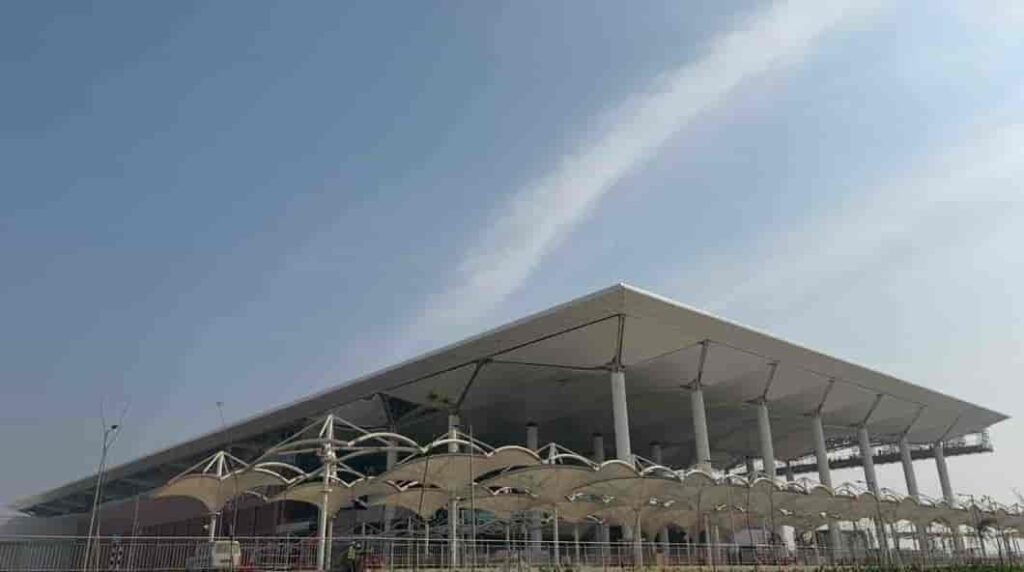
The inauguration of the Noida International Airport, widely known as Jewar Airport, marked a landmark moment in India’s aviation and infrastructure expansion. Positioned as one of the country’s largest and most ambitious greenfield airport projects, its launch has been seen as a strategic move to decongest existing aviation hubs and unlock new economic potential across northern India.Located in Jewar in Uttar Pradesh’s Gautam Buddha Nagar district, the airport has been developed to serve the rapidly growing travel demand of the National Capital Region (NCR), while also acting as a catalyst for industrial, logistical, and urban development in surrounding areas.Why India Needed a Second Major Airport in NCRFor years, the Indira Gandhi International Airport in Delhi has handled the bulk of air traffic in northern India. With passenger numbers steadily rising, the airport has been operating close to its maximum capacity, leading to congestion, delays, and operational strain.The idea of developing a second airport in the NCR was not just about expansion, but about redistributing aviation load and future-proofing infrastructure. The Noida International Airport was conceptualised to address these issues while supporting the long-term growth of one of India’s busiest urban corridors.Its location near the Yamuna Expressway provides strategic access not only to Delhi but also to key cities like Noida, Greater Noida, Ghaziabad, Agra, Mathura, and Aligarh. This makes it a regional hub rather than just an alternative airport.Scale, Design and Multi-Phase DevelopmentWhat sets the Noida International Airport apart is its scale and long-term vision. Unlike many existing airports that evolved through gradual expansion, this project has been planned from the outset as a multi-phase mega infrastructure development.In its first phase, the airport has been designed to handle around 12 million passengers annually, with a single runway and terminal. However, the long-term plan is far more ambitious. Once fully developed, the airport is expected to:Handle over 70 million passengers per yearOperate multiple runwaysInclude expansive cargo terminals and logistics parksSupport maintenance, repair, and overhaul (MRO) operationsThis phased approach ensures that the airport can scale alongside demand, making it a future-ready aviation hub.Focus on Sustainability and Modern InfrastructureOne of the defining aspects of the project is its emphasis on sustainability. The airport has been planned as an environmentally responsible infrastructure project, incorporating:Energy-efficient terminal designsWater conservation systemsReduced carbon footprint strategiesSustainable construction practicesGlobally, there has been increasing focus on green aviation infrastructure, and the Noida International Airport aligns with this shift by aiming to become one of the more eco-conscious airports in the region.Connectivity and Integration with Transport NetworksA major strength of the Jewar airport lies in its planned connectivity. The project is not being developed in isolation but as part of a larger, integrated transport ecosystem.The airport is expected to be connected through:The Yamuna Expressway and Eastern Peripheral ExpresswayProposed metro rail extensionsRegional Rapid Transit Systems (RRTS)High-speed rail links in the futureThis multi-modal integration will ensure seamless movement of passengers and goods, significantly reducing travel time and improving accessibility across the NCR and beyond.Economic Impact: A New Growth Engine for Uttar PradeshThe inauguration of the airport is expected to trigger a wave of economic activity in the region. Large infrastructure projects often act as growth multipliers, and Jewar is already witnessing rapid transformation.The airport is likely to:Generate thousands of direct and indirect employment opportunitiesBoost real estate demand in nearby areasAttract domestic and international investmentPromote development of logistics and warehousing hubsPlans for an aerotropolis—a city built around the airport—are also underway, which could include business districts, commercial centres, hotels, and industrial zones.This development is expected to strengthen Uttar Pradesh’s position as a major economic and industrial hub in northern India.Boost to Trade, Cargo and LogisticsBeyond passenger travel, the airport is expected to play a crucial role in cargo and logistics operations. With increasing demand for faster supply chains and export-oriented industries, the need for efficient cargo infrastructure has grown significantly.The Noida International Airport is being developed with dedicated cargo facilities, which will:Facilitate faster movement of goodsSupport export industries in the regionImprove connectivity for perishable and high-value goodsIts proximity to industrial clusters makes it particularly well-suited to serve as a logistics hub.Impact on Travel and Passenger ExperienceFor travellers, the airport is expected to bring noticeable improvements in convenience and efficiency. With reduced pressure on Delhi’s main airport, passengers can expect:Shorter wait timesBetter flight availabilityImproved travel experienceResidents of Noida, Greater Noida, and nearby regions will especially benefit, as they will no longer need to rely solely on Delhi for international travel.A Shift Towards Decentralised Urban DevelopmentThe development of the Jewar airport reflects a broader shift in India’s urban planning strategy—moving away from over-centralisation towards distributed growth models.By creating infrastructure hubs outside major metropolitan centres, the government aims to:Reduce pressure on existing citiesEncourage balanced regional developmentImprove quality of life in emerging urban zonesThe airport is expected to play a key role in shaping the future growth of the NCR, particularly in the Noida-Greater Noida belt.A Defining Moment in India’s Infrastructure StoryThe inauguration of the Noida International Airport is not just about adding another airport to the country’s aviation network. It represents a long-term vision for connectivity, economic expansion, and urban transformation.As air travel continues to grow in India, projects like Jewar airport will play a crucial role in ensuring that infrastructure keeps pace with demand. With its scale, strategic location, and integrated planning, the airport is poised to become one of the most important aviation hubs in the country in the coming years.In many ways, it signals how India is preparing for the next phase of growth—by investing in infrastructure that is not only large in scale but also forward-looking in design and impact.