

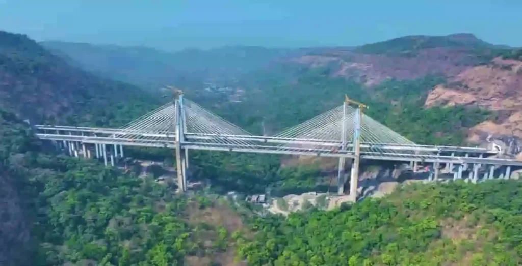
Anji Khad Bridge: India’s First Cable-Stayed Railway Marvel Connecting Kashmir to the Nation
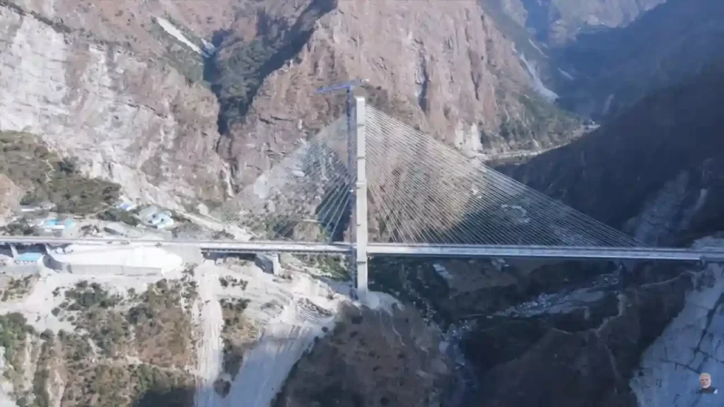
In the rugged hills of Jammu & Kashmir, where steep gorges and fierce winds challenge every builder, a stunning engineering wonder now stands tall. The Anji Khad Bridge is India’s very first cable-stayed railway bridge, a key piece of the massive Udhampur-Srinagar-Baramulla Rail Link (USBRL) project. This 272-kilometer all-weather rail line will finally connect the beautiful Kashmir Valley to the rest of India, ending decades of isolation. Prime Minister Narendra Modi inaugurated it on June 6, 2025, alongside the world’s highest rail bridge over the Chenab River. These bridges mark a historic moment, turning tough Himalayan dreams into reality and opening doors for faster travel, trade, and tourism.Where It Stands and What It ConnectsThe Anji Khad Bridge stretches gracefully across the Anji River, a sparkling tributary of the mighty Chenab, in Reasi district of Jammu & Kashmir. It links the pilgrimage town of Katra (base for the Vaishno Devi temple) to Reasi, about 80 kilometers from Jammu city. This spot sits in the young, shaky folds of the Himalayas – a place with deep gorges, near-vertical walls, earthquakes, and winds gusting up to 213 km/h (almost cyclone strength). Before this bridge, trains had to take long, winding detours. Now, passengers zoom through safely, cutting travel time and costs.Part of the USBRL mega-project, which includes 943 bridges and 36 tunnels, the bridge ensures year-round connectivity. No more snow-blocked roads or floods, trains will run smoothly, carrying people, goods, and hope to Srinagar and beyond.A First in India: Cable-Stayed Design Explained SimplyCable-stayed bridges are like giant clotheslines holding up a road or rail deck. Strong cables stretch from tall pylons (towers) directly to the bridge floor, making them perfect for long spans over deep valleys. Unlike suspension bridges (like Howrah), these are simpler, cheaper, and quicker to build in tough spots.The Anji Khad Bridge shines with these standout features:Total length: 725 meters (about 2,380 feet), with a 473-meter cable-stayed section.Height: 331 meters (1,086 feet) above the riverbed – taller than many skyscrapers.Main pylon: Inverted Y-shape, rising 193-196 meters (633 feet) from foundation – one of the tallest of its kind.Cables: 96 high-tensile cables of different lengths, using 653 kilometers of strands total. They create an asymmetrical design for stability.Deck width: Supports double rail tracks, plus a 12.3-foot service road and 5-foot footpaths on both sides.Train speed: Safe for 100 km/h services like Vande Bharat.Built with 8,200 metric tonnes of steel, it took just 11 months for the main structure. Italian firm Italferr (FS Group) handled design and supervision, their $70 million project won the 2024 ENR Global Best Projects Award for excellence, innovation, and safety.Built for Battle: Surviving the Himalayas’ FuryThe Himalayas don’t play nice. Steep slopes, loose rocks, quakes (Zone V), and howling winds tested every bolt. Engineers used:Seismic-proof tech: Flexible joints absorb shocks.Wind tunnels: Tested for 213 km/h gusts.Sensors everywhere: Integrated health monitoring tracks stress, vibrations, and cracks in real-time.Special concrete: Resists extreme cold (-20°C) and heat.One clever trick? Asymmetrical layout let most work happen from one side, avoiding unstable slopes. Construction used cranes, helicopters for cables, and precision tech, all without harming the fragile ecology.Part of USBRL: Kashmir’s Rail LifelineThe USBRL (started 2002, cost Rs 40,000+ crore) drills through mountains to link Udhampur (on Jammu-Del train line) to Baramulla near Srinagar. Highlights:Chenab Bridge: World’s highest rail arch (359m/1,178 ft), inaugurated same day.Tunnels: 119 km total, including the longest at 12.7 km.Benefits: Srinagar is 3.5 hours from Delhi; apples, saffron to markets fast; jobs, tourism boom.PM Modi flagged Vande Bharat trains from Katra to Srinagar, zipping tourists to Vaishno Devi and Kashmir’s valleys.Global Praise and Real ImpactThe bridge isn’t just Indian pride, it’s world-class. ENR Award beat 120 entries for bridging tough terrain sustainably. Italferr calls it “unprecedented” for India. Locals cheer: Faster pilgrimages, cheaper goods, and army supplies secure.Challenges? Monsoon floods, landslides delayed it years. But grit won, now trains roll where eagles soar.
India’s Kalpakkam Nuclear Reactor Hits Major Milestone
India has achieved a big success in its nuclear energy program. On April 6, 2026, the Prototype Fast Breeder Reactor at Kalpakkam in Tamil Nadu reached first criticality. This means the reactor started a steady nuclear chain reaction on its own. The 500 MWe reactor was fully designed and built in India by Bharatiya Nabhikiya Vidyut Nigam Limited at the Kalpakkam Nuclear Complex. Prime Minister Narendra Modi called it a defining step for India’s nuclear journey. This event moves India into the second stage of its three-stage nuclear power plan, first dreamed up by Dr. Homi Jehangir Bhabha.The success shows years of hard work by India’s scientists in the Department of Atomic Energy. When fully operational, India will be the only country, after Russia, to have a working commercial fast-breeder reactor. It helps India’s clean energy goals by giving steady power with low carbon. This brings the country closer to no net emissions by 2070.What is India’s Three-Stage Nuclear Plan?India has little uranium but lots of thorium. The plan uses a closed fuel cycle to make more fuel over time. Each step leads to the next for long-term power security.In Stage 1, Pressurised Heavy Water Reactors use natural uranium for power. Their waste makes plutonium for Stage 2.Stage 2 uses fast-breeder reactors such as the PFBR. These make more fuel than they use. The PFBR turns plutonium into power and breeds plutonium-239 from uranium-238. Later, it will use thorium to make uranium-233 for Stage 3.Stage 3 will use India’s thorium with uranium-233 for huge amounts of clean energy. This smart plan makes India a leader in nuclear strategy.How the PFBR Works SimplyThe PFBR comes from research at the Indira Gandhi Centre for Atomic Research. It uses mixed uranium-plutonium fuel from old reactor waste. A blanket around the core turns uranium-238 into new plutonium-239 with fast neutrons. This means it breeds extra fuel.It is sodium-cooled and sits next to the Madras power station. Construction started in 2004, and fuel went in during 2024. Waste fuel gets reused, cutting trash. It links Stage 1 to thorium in Stage 3.India’s Nuclear Power TodayIndia has 8.78 GW of nuclear power now. In 2024-25, plants made 56,681 million units of electricity, about 3% of total power. There are 21 working plants and eight buildings.Plans add 18 reactors by 2031-32 to reach 22.38 GW. India has deals with 18 countries for peaceful nuclear workBig Future PlansThe 2025-26 budget starts the Nuclear Energy Mission for 100 GW by 2047. It gives Rs 20,000 crore for small modular reactors. Five home-made ones will run by 2033.BARC builds new designs like the 200 MWe BSMR-200 and others for power and hydrogen. The SHANTI Act of 2025 updates rules and lets some private help under watch.This path mixes money, new laws, and home tech for a strong nuclear future. The PFBR opens doors to thorium power, and less uranium is needed. It creates jobs and cuts coal use for India’s growth.
Amaravati: Andhra Pradesh’s New Capital City Finally Coming to Life After Years of Drama
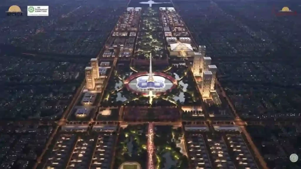
Imagine building a brand-new capital city from scratch – a modern wonder along a mighty river, designed by global experts, powered by green energy, and home to millions. That’s the dream of Amaravati, Andhra Pradesh’s greenfield capital project led by Chief Minister N. Chandrababu Naidu. Once stalled for five long years, this ambitious “people’s capital” or Praja Rajadhani is now buzzing with activity. As of April 2026, projects worth Rs 57,821 crore are underway, with Rs 50,943 crore already grounded. Prime Minister Narendra Modi laid the foundation stone recently, and Naidu promises that Phase 1 will be ready in months. After a decade of twists, turns, protests, and court battles, Amaravati is rising again on the Krishna River banks, ready to be India’s most sustainable city.A Dream Born in 2014: From Bifurcation Blues to Bold VisionAndhra Pradesh lost Hyderabad as its capital after the 2014 bifurcation with Telangana. The state needed a fresh start. Naidu, then Chief Minister, picked Amaravati, a 2,300-year-old site in Guntur district with deep history. Ancient Satavahanas ruled here around 225 BCE, and Emperor Ashoka’s Buddhist stupa (Amaravati Mahachaitya) still whispers of Gautama Buddha’s visits. In the 18th century, zamindar Raja Vasireddy Venkatadri Naidu revived it as a thriving town, building palaces amid fertile Krishna delta lands.Why here? Perfect spot, central, near Vijayawada and Guntur, with great roads, rails, and river views. Naidu announced it on October 22, 2015, with Modi’s foundation stone. The name “Amaravati” means “abode of immortals,” linked to the Amareswara Shiva temple. Singapore’s experts (like Foster + Partners) crafted the masterplan: 217 square km of nine themed sub-cities, Government, Justice, Knowledge, Finance, Health, Sports, Culture, Tourism, and Electronics. At the heart? A green spine like New York’s Central Park, with the Assembly as a 250-meter lily-shaped tower.The Land Pooling Magic: Farmers as True PartnersNo forced takeovers, that’s Naidu’s genius Land Pooling Scheme (LPS) from 2015. Over 27,000 farmers voluntarily gave 33,000 acres. In return:Wet land owners: 1,000 sq yd residential + 450 sq yd commercial plots per acre, plus Rs 50,000/year annuity (rising 10% yearly for 10 years).Dry land owners: 250 sq yd commercial plots per acre + Rs 30,000/year annuity.Landless farmers: Rs 2,500/month pension for 10 years.The Andhra Pradesh Capital Region Development Authority (APCRDA) manages it. Bhoomi puja happened in June 2015; the secretariat and assembly moved to temporary sites by 2017. The Big Halt: Politics, Protests, and a Three-Capitals Twist (2019-2024)Joy turned to pain in 2019. YSR Congress’s Jagan Mohan Reddy won, suspended annuities for 2,903 farmers, canceled pensions for 4,422 families, and ditched LPS for 33,000 acres. He pushed a “three capitals” plan: Amaravati (legislative), Visakhapatnam (executive), Kurnool (judicial). World Bank and AIIB pulled $1 billion in funding. Farmers protested 1,630 days straight, facing lathi charges. The High Court ruled in 2022: Amaravati stays the sole capital. Reddy withdrew the bill in 2021 amid legal heat.The five-year freeze? Cost overruns of 40-45%, roads up 25-28%, buildings 35-55%. The original Rs 51,000 crore budget swelled to Rs 64,910 crore. Infrastructure rusted; investors fled.Revival Under Naidu 2.0: Money Flows, Work Speeds Up (2024-Now)Naidu’s TDP won big in June 2024. He restarted annuities, pensions, and bank loans for plots. Farmers invited to events, Naidu calls them “heroes.” Parliament passed the Andhra Pradesh Reorganisation (Amendment) Bill 2026 on April 1, making Amaravati the permanent sole capital.Funding floodgates opened:World Bank: $800M (first $205M in March 2025) for urban infra, jobs, flood-proofing.ADB: $788.8M loan + $3.64B commitment (2025-2029) via Results-Based Lending.HUDCO: Rs 11,000 crore loan.Centre: Rs 4,200 crore released; state budget Rs 15,000 crore (2024-25), Rs 6,000 crore (2026-27).Land monetization for more cash. A World-Class Green Dream City: What’s PlannedAmaravati won’t just be offices, a smart, carbon-neutral hub for 3.5 million people and 1.5 million jobs by 2050:Renewable power: 2,700 MW from solar, wind, hydro – world’s first 100% green capital. Rooftop solar is mandatory.Transport: Metro, e-buses, EV stations, cycle paths.Tech: Smart grids, IoT traffic, flood drains.Layout: 13 plazas for districts; themed hubs like Knowledge City (universities) and Finance City (banks).Inspired by Amsterdam (canals), Singapore (gardens), and Tokyo (efficiency).Naidu: “Rome wasn’t built in a day, but Amaravati will be India’s growth engine.” Economic survey 2025-26 calls it AP’s powerhouse.Main Features of Amaravati’s Master Plan It is an ambitious blueprint for a world-class, sustainable capital city in Andhra Pradesh. Designed by global experts like Singapore’s Housing and Development Board (HDB) and Foster + Partners, it transforms 217 square kilometers along the Krishna River into a “people’s capital” called Praja Rajadhani. The plan focuses on green living, smart technology, and economic growth for 3.5 million people by 2050. Here are the main features, explained simply.1. Nine Themed Sub-Cities for Balanced GrowthThe city is divided into nine specialized zones, each with a clear purpose:Government City: Core hub with assembly, high court, and offices.Justice City: Courts, legal institutions, and related services.Knowledge City: Universities, research centers, and schools.Finance City: Banks, stock exchanges, and business towers.Health City: Hospitals, medical research, and wellness centers.Sports City: Stadiums, training facilities, and parks.Culture and Tourism City: Museums, heritage sites, and hotels.Electronics and IT City: Tech parks and innovation hubs.Recreational and Residential Zones: Homes, shopping, and leisure areas.These clusters group jobs and homes smartly, cutting travel time and boosting efficiency.2. Central Green Spine: The City’s LungsA massive green spine runs north-south through the heart, like New York’s Central Park or Lutyens’ Delhi. This 5.5 km long, 1 km wide corridor includes:Parks, lakes, and gardens covering at least 60% greenery or water.Walking paths, cycle tracks, and shaded streets.Waterfront development along the Krishna River with promenades and water taxis.It cools the city naturally and hosts events.3. Iconic Architecture and Urban GridGovernment Complex: Star attraction with a 250-meter lily-shaped Assembly tower (inverted lotus symbolizing democracy). High Court and secretariats nearby.13 Urban Plazas: One for each of Andhra’s districts, public squares for markets and festivals.Grid road network: Wide avenues (up to 60 meters), underground utilities (no messy wires), and elevated expressways.Mixed-use neighborhoods blend homes, shops, and offices. 4. 100% Green Energy and SustainabilityAmaravati aims to be the world’s first fully renewable-powered capital:2,700 MW clean power
Delhi Launches EV Policy 2.0 to Fight Pollution and Boost Electric Vehicles
The Delhi government has put up a bold new plan to clean up the city’s air. They released the draft Electric Vehicle Policy 2.0 for 2026 to 2030 on April 11, 2026. This policy, called EV Policy 2.0, offers big cash incentives, tax breaks, and strict rules on petrol vehicles. The Transport Department’s EV Cell put it out for public feedback. People can send comments by email or post for 30 days. The goal is to make Delhi a leader in electric vehicles and cut down on dirty air from cars and bikes. Delhi wants one in every four new vehicles sold to be electric, building on its old policy from 2020.This new draft comes at a time when Delhi battles severe pollution. Vehicles cause a large part of the smog. Two-wheelers make up 67 percent of all vehicles on Delhi roads. The policy targets them first with bans and money help. It mixes rewards for buyers with deadlines to stop old fuel types. Experts call it one of India’s most forward-thinking plans. It aims to turn Delhi into a green transport hub by 2030.Big Cash Incentives for Electric Vehicle BuyersThe policy gives direct money to people who buy electric vehicles. Incentives drop over three years to push fast change. Buyers claim them online and get bank transfers after checks. They tie into the national PM E-DRIVE scheme.For electric two-wheelers up to Rs 2.25 lakh, help starts high. In year one, buyers get Rs 10,000 per kWh of battery, up to Rs 30,000 max. Year two drops to Rs 6,600 per kWh, max Rs 20,000. Year three gives Rs 3,300 per kWh, max Rs 10,000. This makes cheap EV scooters affordable for daily commuters.Electric three-wheelers like auto-rickshaws get fixed amounts. Year one pays Rs 50,000. Year two gives Rs 40,000. Year three offers Rs 30,000. These help drivers switch from CNG to clean power.For N1 goods vehicles up to 3.5 tonnes, incentives hit Rs 1 lakh in year one. Year two pays Rs 75,000. Year three gives Rs 50,000. Small trucks and vans benefit most here.Electric cars up to Rs 30 lakh ex-showroom qualify for extra perks if owners scrap old BS-IV or older cars. First 100,000 buyers get a Rs 1 lakh scrappage bonus. They must scrap within six months of the certificate. This clears old polluters fast. Tax Breaks and Scrappage Bonuses Make EVs CheaperElectric vehicles skip all road tax and registration fees until March 31, 2030. Cars up to Rs 30 lakh get a 100 percent waiver. Strong hybrids get 50 percent off. Luxury EVs over Rs 30 lakh pay full.Scrappage adds more savings. Two-wheeler owners get Rs 10,000 for old petrol or CNG bikes. Three-wheeler drivers earn Rs 25,000. N1 truck buyers pocket Rs 50,000. These bonuses reward people who ditch dirty vehicles for electric ones. The push clears roads of high-emission machines.Strict Bans and Mandates to Force the SwitchThe policy sets hard deadlines for petrol and diesel. No new petrol two-wheeler registrations after April 1, 2028. Only electric bikes and scooters are allowed then. New three-wheeler registrations must be electric from January 1, 2027. No more CNG autos.Commercial fleets face tougher rules. From January 1, 2026, ride-hailing and delivery firms cannot add new petrol or diesel two-wheelers or light goods vehicles up to 3.5 tonnes. BS-VI two-wheelers last until the end of 2026.Government leads by example. All leased or hired official cars will turn electric in 12 months. Delhi runs 3,535 electric buses now. Plans add 2,800 more in phase one and 3,330 in phase two. The goal is to hit 7,500 e-buses by the end of 2026 and 11,000 by 2028. Public transport shows the way.Charging Stations Grow to Support More EVsNo good policy without places to charge. Delhi wants a public charger every 3 km. From hundreds in 2020, it reached 9,000 stations by early 2026. Battery swap spots hit 234. Target will jump to 30,000 chargers soon.The government helps installers with cheap land in parking lots. It reimburses 100 percent of the state GST on advanced batteries for swaps. New buildings must have EV-ready spots in 20 percent of parking. Lower power rates for charging make it cheap. Sellers must add chargers at dealerships. These fights range from fear to speed in daily use.Past Success and Road AheadDelhi’s first EV policy from 2020 worked well. EVs now make 14 percent of new sales, above India’s 8 percent average. Over 86,000 EVs registered since the start. Two and three-wheelers lead uptake. Charging grew fast, too. The Transport Department runs the show with an EV Cell. A State EV Board checks progress. Funds come from pollution fines and the Air Ambience Fund. Central FAME money flows through local schemes.Challenges remain. Old subsidy delays frustrated buyers. New rules fix that with fast claims. Land scarcity slows chargers. Retrofitting old cars raises safety concerns. Policy adapts with open data on stations and loan help.Delhi beats many states in EV share and chargers. It teaches others: mix money, rules, and infra. National goals like PM E-DRIVE align perfectly. By 2030, Delhi eyes top global spot for green rides.
GIFT City Updates: IPO Withdrawal, New Initiatives, and Growth Milestones in Gujarat’s Financial Hub
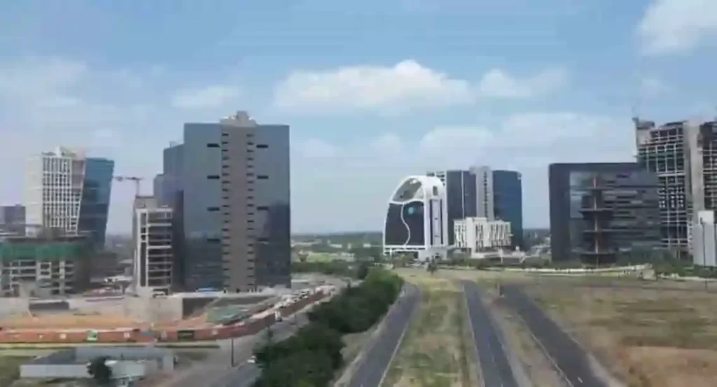
Gandhinagar, April 2026 – Gujarat International Finance Tec-City (GIFT City) saw key developments this week. These include the withdrawal of the first GIFT City IPO, the launch of an industry-academia collaboration series, Niyam Group’s insurance authorization, and recognition as India’s first fully operational global financial hub. All details are from official sources, IFSCA, and company statements.XED Executive Development Withdraws $12 Million IPOXED Executive Development, the first company to launch an IPO in GIFT City, withdrew its $12 million share sale on Monday.Reason: Weak investor demand due to global uncertainties.Subscription: Only 5% of the offer size, per NSE International Exchange data, despite extensions.Company statement: “We withdraw in the current environment and plan to return at a better time.” Informed GIFT City-IFSC and exchanges.Challenges: KYC bottlenecks for retail investors; caution from institutions amid volatility and low liquidity.Impact: Industry calls it a setback for GIFT City’s IFSC ambitions against global hubs.GIFT City Launches Industry-Academia Roundtable SeriesGIFT City started its Industry-Academia Roundtable series to align talent with IFSC needs.First event: Held recently in GIFT City with leaders from Ahmedabad/Gandhinagar universities, tech firms, and GCC companies.Focus areas:Curriculum alignment with financial services, fintech, and tech.Structured internships and live projects.Research collaboration and talent pipelines.Quotes:Ms. Shefali Gaur, IBM: “Future workforce needs adaptability, digital fluency, and problem-solving. These platforms build employable talent.”Mr. Nimay Kalyani, University of Wollongong: “Evolve from alignment to integration for job-ready graduates.”Future: Expand to key Indian cities to boost employability and partnerships.Niyam Group Gets Tier 2 Insurance Intermediary ApprovalNiyam Group received IFSCA approval as a Tier 2 Insurance Intermediary Office (IIO) in GIFT City.Launch: January 2026 by insurance veteran Bobby Swarup (20+ years experience).Focus: Bring reinsurance capacity to India; supports Viksit Bharat 2047.Key approvals: Lloyd’s of London for Syndicate 2047; first IIO to offer Lloyd’s capacity from GIFT City.Principal Officer: Sumit Aneja, based in GIFT City, to scale operations.Quotes:Aneja: “Focused on building a high-performing team for Vision 2047.”Company: “Grateful to IFSCA; GIFT City key to India’s re/insurance growth.”GIFT City: India’s First Fully Operational Global HubGIFT City is now India’s first fully operational global financial and IT hub.Vision: Started under PM Narendra Modi as Gujarat CM; advanced by CM Bhupendra Patel.Features: Policy-driven center with financial services, tech, regulatory ease, and infrastructure.Goal: Serve India and the world by competing with global financial centers.Status: Transformed into a vibrant ecosystem per official press release.Recent Developments RecapXED IPO Withdrawal: First GIFT City IPO ($12M) pulled due to 5% subscription amid global issues and KYC hurdles.Industry-Academia Roundtables: New series bridges education and fintech needs; first event with universities and firms like IBM.Niyam Group Approval: Tier 2 IIO license; first to offer Lloyd’s Syndicate 2047 capacity; led by Sumit Aneja.Hub Milestone: Fully operational global finance/IT center, envisioned by PM Modi and advanced by CM Bhupendra Patel.Future Plans for ExpansionGIFT City targets rapid scaling post-2026:GCCs and Innovation: Priority on Global Capability Centres (GCCs), Global Innovation Centres (GICs), and centres of excellence for cost advantages.Workforce Goal: 100,000 jobs by 2030.Infrastructure: Add 10.25M sq ft (DTA, ~52,300 jobs) + 12.26M sq ft (SEZ, ~84,600 jobs) by FY2030; total 136,900+ new jobs.Residential: 7,500 units by 2030 for a live-work balance.Talent Focus: Deeper skills via partnerships, regulatory sandboxes, and social infrastructure. Outreach: Global events like Davos drive commitments beyond banking.Comparison: GIFT City vs. DIFC (Dubai) and SingaporeGIFT City competes effectively with established hubs, emphasizing India’s market access and low costs.FeatureGIFT City DIFC (Dubai) gift.Singapore Tax Exemptions100% for 10 years (profits, gains, no GST/MAT)0% on qualifying Free Zone income; 50-year holiday possibleAttractive rates, treatiesOperational CostsLowModerateHighRegulationsIFSCA: Flexible, global standardsStrict, investor-friendlyBusiness-friendly, GST exemptionsMarket AccessIndia’s 1.4B populationMiddle East/AfricaAsia-PacificSetup EaseSimple for funds/fintechUSD 50M AUM min for someHigh but costlyBest ForCost-effective offshore financeHigh-net-worth family officesEstablished tradingGIFT City excels in tax holidays and proximity to India’s growth, while DIFC offers long-term certainty for larger assets.Strategic ImportanceDespite IPO hiccups, GIFT City’s momentum – via reinsurance, talent initiatives, and expansions- positions it as a rival to offshore hubs like Singapore/Mauritius. It supports India’s Viksit Bharat 2047 vision with reinsurance capacity and fintech innovation.These updates show GIFT City’s push in finance, talent, and reinsurance despite challenges like the IPO pullback. The hub strengthens Gujarat’s role in India’s economy.
PM Modi Inaugurates Ahmedabad-Dholera Expressway
Imagine zipping from the bustling heart of Ahmedabad to the rising star of Dholera in just 45 minutes, instead of a bumpy two-hour crawl. That dream roared to life on Tuesday when Prime Minister Narendra Modi cut the ribbon on the stunning Ahmedabad-Dholera Expressway, a sleek, Rs 5,100 crore marvel of engineering that’s set to supercharge Gujarat’s economy.These developments focus on roads, railways, semiconductors, renewable energy, and urban mobility.Ahmedabad-Dholera Expressway Now OpenPM Modi inaugurated the Ahmedabad-Dholera Expressway on March 31.Cost: Over Rs 5,100 crore.Type: Access-controlled highway.Length: Approximately 110 km.Travel time: Reduces from 2 hours to 45 minutes.Speed limit: Up to 120 kmph.Benefits: Improves connectivity to Dholera Special Investment Region (DSIR), boosts industrial growth, and supports economic development.Road and Highway ProjectsThe Prime Minister laid foundation stones for key road upgrades:Four-lane Idar-Badoli bypass with paved shoulders.Upgrade of Dholavira–Mauvana–Vauva–Santalpur section (Package II) of National Highway 754K to a two-lane with paved shoulders.These projects aim to reduce travel time, enhance safety, and support logistics.Flyovers for Urban Traffic ReliefTwo flyovers were addressed to ease congestion in Gandhinagar and Ahmedabad:Inaugurated: Flyover at PDPU Junction on Gandhinagar-Koba-Ahmedabad Airport Road (handles over 1.4 lakh vehicles daily).Foundation laid: Flyover at Bhaijipura Junction on Gandhinagar-Koba-Airport Road (includes parking facilities below).These will cut commute times to the airport and state capital.Keynes Semicon Plant InauguratedPM Modi inaugurated the Keynes Semicon plant in Sanand, Ahmedabad.Milestone: Second semiconductor plant in India to start commercial manufacturing.Initial product: Advanced Intelligent Power Modules (IPMs) with 17 chips each.Applications: Automotive and industrial power systems.Client: Alpha & Omega Semiconductor (California-based).Full capacity: 6.33 million units per day.This strengthens India’s semiconductor sector.Railway Infrastructure UpgradesDedicated to the nation:Kanalus-Jamnagar doubling project (28 km, part of 111.20 km Rajkot-Kanalus project).Quadrupling of the Gandhidham–Adipur section (10.69 km).These improve train frequency and freight movement.Renewable Energy BoostPM Modi inaugurated Khavda Pooling Station-2 and associated transmission systems.Capacity: Evacuates 4.5 GW of renewable energy.Role: Supports Gujarat’s solar and wind power grid.Gujarat now leads India in solar power generation, as highlighted by the PM.PM Modi’s Remarks on Gujarat’s ProgressDuring the public address, PM Modi highlighted Gujarat’s leadership in renewable energy. He recalled establishing a multi-technology solar park in 2010 as Chief Minister, which laid the foundation for the state’s solar growth.Broader ImpactThe projects cover connectivity, industry, green energy, healthcare, and tourism. They align with national goals for infrastructure and sustainable development. Official sources confirm all details from the Prime Minister’s Office and the Gujarat government announcements.
From Power Corridors to Cultural Eternity: Yuge Yugeen Bharat Museum as World’s Largest by 2026
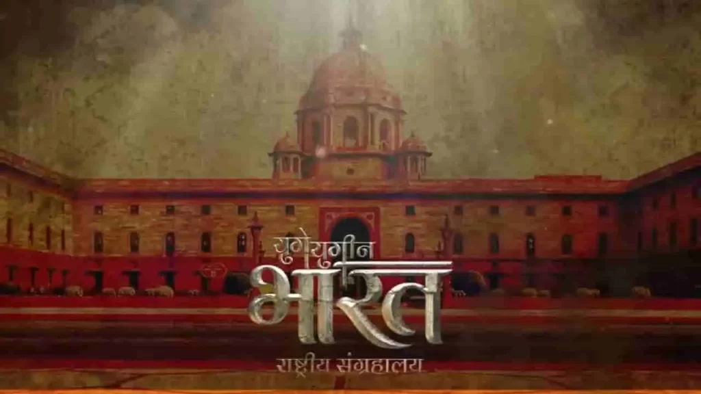
In a transformative pivot from colonial legacies to civilizational pride, India’s historic North and South Blocks on Raisina Hill are shedding their administrative mantle to birth the Yuge Yugeen Bharat Museum, poised to claim the title of the world’s largest museum. Spanning 1.55 lakh square meters (with over 80,000 sqm of display space across 950 rooms), this behemoth will chronicle 5,000 years of Bharat’s journey, from Indus Valley seals to modern manuscripts. The first gallery is expected to open in the North Block by late 2026, featuring 30 thematic spaces over three years and showcasing 80,000–1 lakh artefacts sourced from national vaults, state collections, and ASI treasures.Culture Secretary Vivek Aggarwal revealed to The Times of India: the inaugural “Time and Timelessness” gallery will spotlight 100 pivotal relics – think Indus Valley terracotta hourglasses (2500–1750 BCE), Mauryan edict pillars (3rd century BCE), Gupta Surya sculptures (5th century CE), the iconic 13th-century Konark Sun Wheel, and Chola Nataraja bronzes (10th–11th century CE) – offering a philosophical portal into India’s eternal ethos.Colonial Bastions Reborn: North-South Blocks’ Historic ShiftOnce the nerve center of British Viceregal power and post-Independence governance, these Edwin Lutyens-designed edifices witnessed the scars of Partition, Emergency deliberations, and triumphs such as the GST rollout, the abrogation of Article 370, and Swachh Bharat. For 95 years, South Block housed the PMO under 16 leaders from Nehru to Modi; Cabinet meetings echoed here until February 2026’s poignant finale.PM Modi’s February 13 dedication of the new PMO, rechristened ‘Seva Teerth’, alongside ‘Kartavya Bhavans’ signaled the epochal change. Ministries like Home, Finance, Personnel, External Affairs, and CBI have relocated to these tech-savvy, green workspaces on Kartavya Path, freeing the blocks for “adaptive reuse.” The Union Cabinet hailed it as a leap from “power-centric” rule to “service-oriented” Viksit Bharat, preserving architecture while infusing modern museology.Thematic Tapestry: 5,000 Years in 30 GalleriesCurated across eight zones, the museum weaves politics, art, spirituality, and innovation:Ancient Foundations: Indus artefacts from Kalibangan, Harappan seals.Classical Glory: Mauryan edicts, Gupta gold coins, Ajanta murals.Medieval Majesty: Chola bronzes, Vijayanagara scrolls, Mughal miniatures.Freedom to Future: INA trials, Constitution drafts, space tech replicas.Expect immersive audio-visuals, digital holograms, manuscripts, coins, and murals, all from a mapped pool of 20 lakh objects. Indo-French synergy elevates it: a December 2024 pact with France Museums Development pairs India’s heritage with Louvre-caliber expertise. Arcop Associates leads design under Thai architect Kulapat Yantrasast (Louvre redeveloper, LA’s Academy Museum), blending adaptive heritage with UNESCO/ICOM standards.Seamless Spectacle: Engineering Visitor DreamsAnticipating 10 million annual visitors (50,000 daily), accessibility reigns: ramps for PwD, seamless flows sans Raisina security snarls. A proposed underground tunnel – morphing into a subterranean cultural corridor- will link North-South Blocks, letting explorers glide between eras undetected. Restoration strips post-Independence partitions, reviving Lutyens’ grandeur amid sustainable tech. Culture Minister Gajendra Shekhawat eyes first verticals by 2027, eclipsing the Louvre’s footprint.FeatureYuge Yugeen BharatLouvre (Paris)Total Area1.55 lakh sqm~72,735 sqmDisplay Space80,000+ sqm~40,000 sqmArtefacts80,000–1 lakh~380,000 (38,000 displayed)Timeline Span5,000 years (Indus–Modern)10,000 years (global)Galleries30 across 8 zones35+ departmentsAnnual VisitorsProjected 10 million9.6 million (2024) Tourism Tsunami and Legacy LinkThis Central Vista crown jewel joins the PM Museum and digitised Archives, amplifying cultural mapping. Replacing Janpath’s National Museum, it repositions Delhi as a heritage hub, drawing global gazes to Raisina’s reinvention. As North Block readies its debut, Yuge Yugeen Bharat isn’t exhibiting; it’s Bharat’s soul, timeless and triumphant, inviting generations to reclaim their continuum.
Mumbai-Pune Missing Link Now Open: World’s Widest Tunnel Ends Ghat Nightmares
The Mumbai-Pune Expressway’s Missing Link opened on May 2, 2026. This 13.3-km engineering marvel now carries traffic smoothly. It skips the dangerous Khandala Ghat with its hairpin turns and traffic jams. The Maharashtra State Road Development Corporation (MSRDC) finished the project just in time for Maharashtra Day. Deputy Chief Minister Eknath Shinde cut the ribbon. Vehicles now zip through in 25-30 minutes less time. Safe speeds reach 120 km/h. The main tunnel holds a Guinness World Record as the widest highway tunnel on the planet. The old ghat section tortured drivers for years. Trucks clogged narrow lanes. Families slept in cars overnight. Ambulances crawled slowly. Landslides hit during monsoons. The new link brings huge relief. It starts at Khalapur toll plaza on the Mumbai side. It ends at Kusgaon near Lonavala and Sinhagad Institute. Total distance shortens by 6 km. Over 50,000 vehicles use the expressway daily. This bypass makes travel faster and safer for everyone.Stunning Engineering: Tunnels, Bridges, and Safety FeaturesThe Missing Link blends cuts, tunnels, viaducts, and flyovers. It features eight lanes with full access control. No more slow trucks in the way.Twin Tunnels Shine BrightTunnel 1 stretches 8.7 km long. Its internal width measures 23.5 meters. This makes it the world’s widest highway tunnel. Guinness confirmed the record after inspectors visited. Tunnel 2 runs 1.67 km. Both handle bidirectional traffic. Each side has four lanes plus shoulders and emergency areas. Fire-proof walls protect users. Jet fans ventilate air. CCTV watches every spot. SOS phones sit every 500 meters. Teams finished electrical and mechanical testing right before opening.Cable-Stayed Bridge Steals the ShowThis bridge spans 650 to 950 meters. Its deck sits 100-125 meters high. The pylon towers 183 meters total. It withstands winds up to 250 km/h. Workers erected the girder in March 2026. They completed 98% of the deck slab. It’s now Maharashtra’s tallest bridge of this type.Other Key PartsA 900-meter viaduct rises 60 meters high. Cut-and-cover tunnels ease tight spots. Flyovers speed up joins. Toll plazas at Khalapur, Talegaon, and Shedung got wider. Hazardous cargo bans keep tunnels safe. No heavy trucks or gas tankers allowed inside.ComponentLength/SizeStatus (May 2026)Key FactMain Tunnel8.7 km, 23.5m wideFully OpenGuinness World RecordEscape Tunnel1.67 kmFully OpenTop Safety FeatureCable Bridge650-950m, 183m tallFully OpenTallest in MaharashtraViaduct900mFully Open60m HighOverall Project13.3 km100% CompleteOpen Since May 1Long Road of Delays Ends in TriumphPlanning started in 2018 with a budget of Rs 6,695 crore. Delays piled up from weather, tough terrain, and COVID. Targets slipped from March 2024 to January 2025, then September and December 2025. Finally, April 30 marked civil works done. Trials followed quickly. MSRDC pushed 2,000 workers hard. Over 1,500 focused on tunnels alone. They worked round the clock.Recent chaos sped things up. Ram Navami traffic jams and tanker flips trapped thousands. MNS chief Raj Thackeray criticized slow work. Deputy CM Shinde ordered emergency plans. MSRDC MD Anilkumar Gaikwad promised action. “Civil works wrap by April 30; trials follow,” he said. The team delivered.Toll collection starts in 2030 for 15 years. It recovers costs over time. Slight toll hikes come with the expressway upgrade. Drivers agree the value beats the price.Relief Replaces Ghat Horror StoriesThe 19.8-km Khopoli-Khandala Ghat had 24 sharp bends. Narrow lanes mixed cars and trucks. Monsoon landslides closed roads often. Kids missed school. Patients reached hospitals late. Ambulances fought for space. One tanker crash blocked traffic for 32 hours. Families ran out of food and water.Now, the Missing Link changes everything. No more ghat climbs. Straighter inland paths replace twists. Safer barriers and lighting guide drivers. Higher speeds cut travel time. Pune-bound lanes opened first. Mumbai-bound finished the final 6 meters on time. Families cheer the smooth ride.Part of Maharashtra’s Road BoomThis project fits Deputy CM Devendra Fadnavis’ big infra plans. The Samruddhi Mahamarg sets records too. MSRDC leads India’s road revolution. The Missing Link connects futures. It saves time, cuts accidents, and boosts business. Trucks move goods faster. Tourists reach Lonavala easy. Daily commuters gain hours weekly.Two days after opening, drivers share joy online. No jams. Quick trips. Safe paths. The ghat nightmare fades. Concrete and steel reclaimed lives. Maharashtra celebrates a new era of fast, safe travel. The world’s widest tunnel proves Indian engineering rules the road.
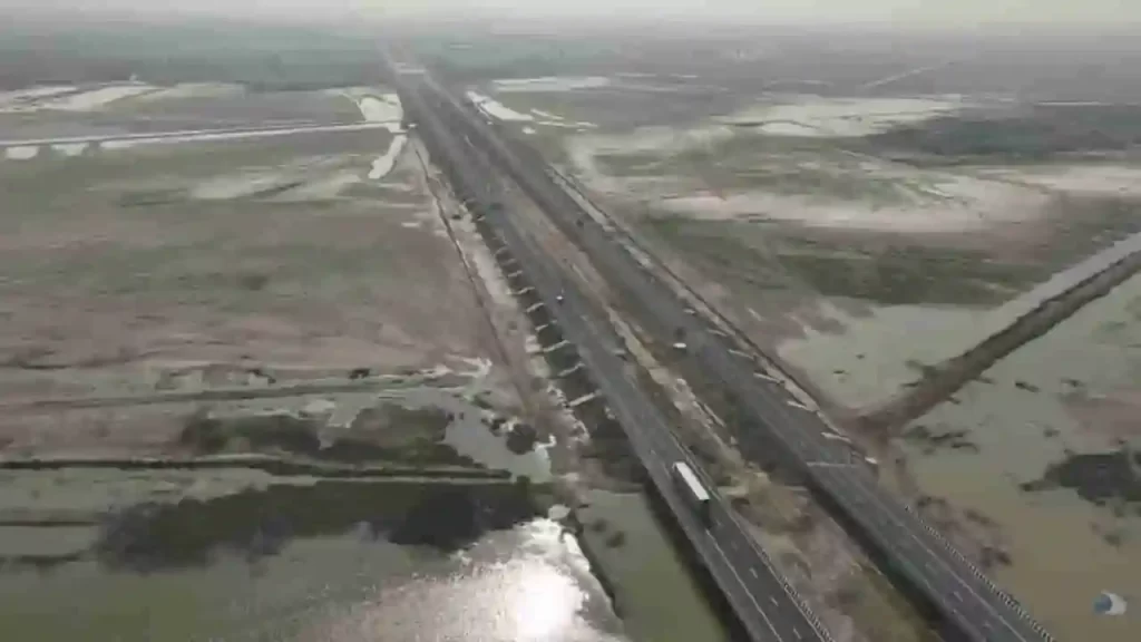
Raipur-Vizag Expressway: Forests and Hills to Link Heartland to Coast in 6 Hours Flat

India’s infrastructure revolution accelerates with the Raipur–Visakhapatnam Expressway (NH-130CD), a 464-km six-lane greenfield marvel threading Chhattisgarh’s forests, Odisha’s mineral belts, and Andhra Pradesh’s Eastern Ghats. Slated for December 2026 completion at ₹16,482–20,000 crore under Bharatmala Pariyojana Phase-I, this Economic Corridor (EC-15) shrinks the 595-km NH-26 slog – from 12–13 hours to just 5–7 hours – fueling exports, tourism, and tribal upliftment.Prime Minister Narendra Modi laid the foundation stone in November 2022, igniting construction across 19 packages via the Hybrid Annuity Model (HAM). South Korean firm YONGMA Engineering crafted the Detailed Project Report (DPR), with most stretches under active build by giants like Dilip Buildcon, HG Infra, Adani Transport, and NKC Projects. Tunnels pierce Ghat valleys – a 2.9-km twin bore in Koraput nears 90% completion, boasting jet fans, fire systems, and SOS every 200m.Route Breakdown: From Abhanpur to SabbavaramKicking off at Kurud/Abhanpur (Raipur district) on NH-30/NH-130C/SH-22, it slices southeast:Chhattisgarh (4 districts, ~125 km)Raipur → Dhamtari (Package-1: Abhanpur-Magerlod, Shalimar Corp.)Kanker (Package-2: Sargi-Basanwahi, Dilip Buildcon; via Sarona)Kondagaon (east of Keskal)Border at Marangpuri/Salna (Package-3: KMV Projects)Odisha (2 districts, ~214 km)Nabarangpur (Packages 1–4: Sunapali-Raighar-Umerkote-Nabarangpur; NKC, Barbrik, Adani)Koraput (Packages 5–11: Borigumma-Dasamantpur-Koraput-Sunabeda-Pottangi; HG Infra, DRA Infracon; 3 pending notices). Tunnels and noise barriers shield Indravati National Park greenery.Andhra Pradesh (Vizianagaram-Visakhapatnam, ~125 km)Parvathipuram Manyam-Vizianagaram (Packages 1–3: Aluru-Jakkuva-Korlam-Kantakapalle; HG Infra, NKC, PSK)Ends at Sabbavaram Interchange on NH-16 Golden Quadrilateral, linking Visakhapatnam Port. ROB over Araku rail line; land hurdles linger in final stretches.Access-controlled for 100 km/h speeds, it hugs NH-26 strategically, with sustainable medians, tree-lined edges, and Ghat eco-shields.SectionLength (km)Key PackagesProgress NotesChhattisgarh~1251–3Viaducts, earthwork advancingOdisha~2141–11Koraput tunnels 70–90%; Nabarangpur 70%AP~1251–4Interchange/Fastag ready; land acquisition delaysEconomic Lifeline: Ports, Minerals, and MarketsTethering Raipur’s steel-coal hub to Vizag Port slashes logistics costs, supercharging exports to East Asia (China, Japan, Korea). Mineral-rich Chhattisgarh-Odisha gain freight efficiency; industries sprout along spurs. Farmers hail land value surges – from ₹15 lakh/acre to ₹1.5 crore – with fair compensation fueling hope: “What we lost turns into a better future,” says Vizianagaram’s Srinivasulu. Truckers like Vishal foresee day trips: “One-and-a-half days to nighttime arrivals.” PM Gati Shakti vision integrates it with East Coast Corridor (Kolkata-Kanyakumari).infra.Tourism and Tribal TransformationUnlocks Dandakaranya’s hidden gems: Araku Valley coffee trails, Sitanadi/Indravati sanctuaries, Jagdalpur’s Chitrakoot Falls. Remote spots like Kanker, Koraput, and Borigumma integrate via faster access to markets/services, spawning jobs in hospitality, realty, and agro-processing.Future Web: National and Global ReachBharatmala spurs eye NCR-CMC links: Bathinda-Hisar-Jaipur-Gwalior (Chambal bridges); Ludhiana-Patiala-Narnaul-Alwar; Paradeep-Raxaul Eastern Corridor loop. Ties to Delhi-Mumbai Expressway, Yamuna Eway, Amritsar-Jamnagar – even Nepal – forge a pan-India artery.As cranes hum near Kothavalasa bridges, this corridor embodies Bharat’s build: not roads, but rivers of opportunity carving equity from terrain. By 2026, Raipur-Vizag won’t just connect – it’ll catalyze destinies.
Shiva’s Stadium: Varanasi’s New Cricket Temple Blends Mythology, Modernity, and Green Power
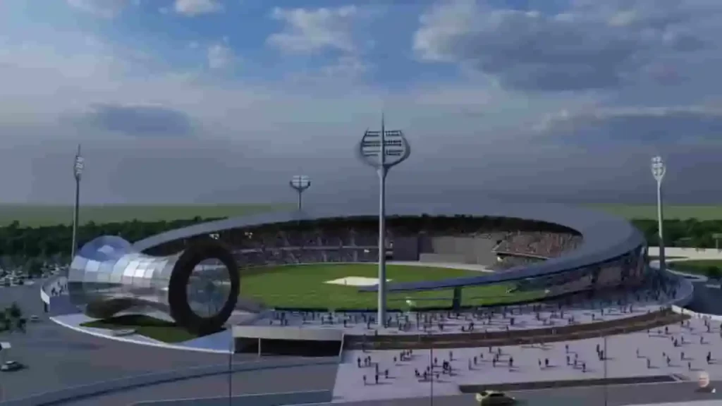
Amid the eternal ghats of Kashi, where Lord Shiva is said to have founded the city as his divine abode, a new landmark is emerging that marries cricket’s feverish passion with the city’s spiritual soul. The Varanasi International Cricket Stadium, under rapid construction in Gajari village (Raja Talab tehsil, 22 km from the sacred Dashashwamedh Ghat), promises to redefine sports venues in India. With a ₹452 crore price tag and a 30,000-seat capacity, this project, launched by Prime Minister Narendra Modi in September 2023, stands over 90% complete. District Magistrate Satyendra Kumar told ABP Live: “Construction is organized and on track for handover by late April, with floodlights up, premium grass turf installed, and seating finalized. Quality and Varanasi’s cultural heritage are priorities.”Divine Design: Every Element Echoes ShivaWhat sets this stadium apart is its immersive Shiva-themed architecture, turning a sports arena into a living tribute to ‘Bholenath.’ Viral images, shared by BJP leader @naveenjindalbjp on X, showcase trishul-shaped floodlights that pierce the skyline like Shiva’s weapon, igniting online buzz: “Perfect tribute to Lord Shiva in Kashi, the energy will be unmatched!” and “Trishul rules in Shivji ki Nagri.” The crescent-shaped canopy symbolizes the moon in Shiva’s jatamakuta (matted locks), while the dome-like media centre replicates the damru, his rhythmic instrument that beats the universe’s pulse. Outer walls feature intricate belpatra (bael leaf) motifs, sacred to Shiva, and the seating cascades in ghat-inspired steps, evoking the Ganga’s ritual stairs where devotees gather for aarti.BCCI Vice President Rajeev Shukla hailed it as visionary: “From Shiva-inspired architecture to solar-powered design, it represents sustainable, inclusive venues rooted in heritage.” This isn’t mere aesthetics; it’s cultural synergy. Varanasi, revered as Shiva’s earthly home in Hindu lore, now channels that mystique into cricket, blending the roar of crowds with the city’s devotional hum.Pitch Perfection and Cricketing NurseryAt the heart lies a state-of-the-art playing field with nine curated pitches: four red soil (for bounce and spin), three black soil (for seam movement), and two hybrid mixes. Modeled after top venues like Lucknow’s Ekana Stadium and Ahmedabad’s Narendra Modi Stadium, these offer versatile conditions to test international stars and hone domestic talent. The outfield uses premium grass with advanced sub-surface drainage, monsoon-proofed for uninterrupted play.Beyond the boundary, a dedicated cricket academy includes dormitories for 100 trainees – a boon for Uttar Pradesh’s budding players. UPCA officials envision it as North India’s next powerhouse, scouting from local maidans to global arenas.Green Revolution: Solar, Recycling, and EV PioneersSustainability is woven into the blueprint. Solar panels will power operations, slashing carbon footprints in a city grappling with Ganga pollution. A comprehensive water recycling system reuses rainwater and greywater for irrigation, aligning with national Swachh Bharat goals. Standout? An on-site EV recharging station, “We’re probably the first stadium to install one,” says a UPCA official, future-proofing for electric team buses and fan vehicles amid India’s green mobility push.These features position Varanasi as a model for eco-stadiums, especially as climate change threatens Indian pitches with erratic weather.Timeline and Trials: From Foundation to FloodlightsLaunched amid fanfare in 2023, progress accelerated post-2025 monsoons. Early 2026 saw structural steel framing complete, followed by roofing and electrics. Speculation swirled about IPL 2026 hosting, fueled by the April deadline, but UPCA clarified to TOI: “Not this season; focus is readiness for internationals.” Whispers of 2027 ODI World Cup matches add intrigue, with the venue eyeing BCCI approval for prime fixtures.Challenges? Logistical hurdles in rural Gajari were met with efficient supply chains, ensuring the April handover.A Game-Changer for Varanasi and Indian CricketFor Varanasi’s economy, reliant on tourism and festivals, it promises jobs, hospitality booms, and events blending cricket with bhajans or cultural nights. Nationally, it underscores PM Modi’s infrastructure vision: 11 new UP stadiums since 2017, elevating the state from backyard cricket to world-class hubs.