

Zojila Tunnel: Asia’s Longest High-Altitude Road Link Burrowing Through Himalayan Fury
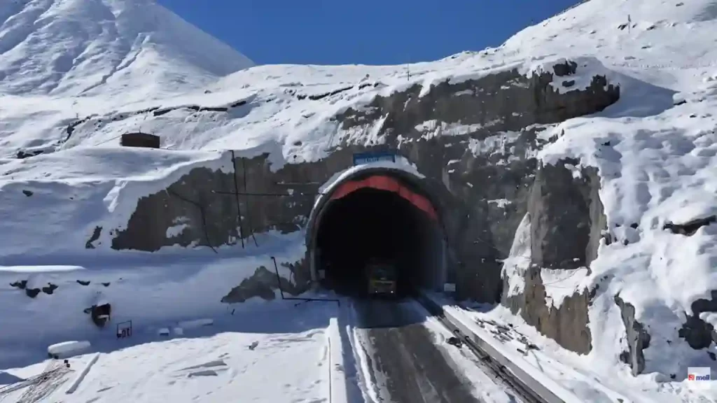
High in the snow-capped Himalayas, where blizzards rage and temperatures plunge to minus 25 degrees Celsius, workers are carving out one of India’s boldest engineering feats. The Zojila Tunnel, set to be Asia’s longest bidirectional highway tunnel at high altitude, promises to end Ladakh’s winter isolation forever. Stretching 13.15 kilometers under the notorious Zojila Pass, this horseshoe-shaped, single-tube, two-lane tunnel will connect Srinagar in Jammu & Kashmir to Drass in Ladakh’s Kargil district. As of April 2026, excavation stands at an impressive 90-95% complete, with just 1-1.25 kilometers left before the big breakthrough in April-May 2026. Led by Hyderabad’s Megha Engineering and Infrastructures Limited (MEIL), the Rs 6,809 crore project defies avalanches, rockfalls, and extreme cold to deliver year-round road access, a game-changer for civilians, soldiers, and the economy.The Perilous Zojila Pass: Why the Tunnel is a LifesaverZojila Pass sits at 11,578 feet (3,528 meters) on the Srinagar-Kargil-Leh highway – a narrow, twisting nightmare prone to heavy snow, landslides, and avalanches. For seven months each winter (October to April), it shuts down completely, stranding Ladakh. Army convoys crawl at 10-15 km/h; civilians face 3-4 hour ordeals over 40 km of ice. Fresh tragedies, like the March 2026 avalanche killing seven near Zero Point, highlight the urgency.The tunnel changes everything. Vehicles zip 13 km straight at safe speeds, slashing Srinagar-Leh travel by 3.5 hours (to about 11-12 hours total). No more seasonal blockades, apples, saffron, and tourists flow freely; troops rush heavy gear to borders with Pakistan and China. It’s strategic gold for India’s Line of Actual Control security.Drilling Through Hell: Progress Amid Sub-Zero BattlesWork kicked off in April 2021 after PM Modi laid the foundation in 2018. MEIL took over in 2020, beating initial Rs 12,000 crore estimates down to Rs 5,500-6,809 crore using smart tech. Divided into two parts:Part 1 (100% done): 17 km approach road from Sonamarg Tunnel to Zojila’s western portal – includes two mini-tunnels, seven avalanche shelters, snow galleries, and four bridges.Part 2 (Main Tunnel): 12 km excavated from both ends (Baltal in Kashmir, Minamarg in Ladakh). Concrete lining covers over 2 km already.Breakthrough ahead: Tunnellers meet mid-2026, then 8-10 fronts tackle finishing, safety gear. Full opening? February-May 2028, ahead of the old 2030 deadlines despite COVID, a 2024 militant attack, and brutal weather. 1,200 workers battle -18°C nights, snowdrifts, water ingress, and fragile geology using New Austrian Tunneling Method (NATM) – drill-blast-support cycles.Winter warrior mode: Heated camps with 24/7 power/hot water, on-site cabins, machine heaters. Recent snows (over a foot) didn’t stop them – teams clear paths round-the-clock.Engineering Marvel: Safe, Smart, and Storm-ProofSpain-designed with European/North American standards, the tunnel is not a basic bore:Specs: 7.57m high/wide, two lanes + 1.5m emergency walkway.Every 750m: 40m refuge bays for breakdowns.Tech wonders: SCADA smart system (CCTV, radio, UPS, ventilation); auto fire detection/suppression.Snow shield: 6 km of catch dams, blast walls, deflectors outside.Seismic savvy: Faces Zone V quakes, high winds; sensors monitor health.Union Minister Nitin Gadkari hailed it in Parliament: 70% done (earlier 2026 update), inviting Speaker Om Birla to see. Ladakh’s Chief Secretary reviewed in 2025: 12 km done, on the 2028 track.Boom for Ladakh: Tourism, Trade, and TroopsZojila Tunnel will transform Ladakh’s tourism from a short summer rush into a year-round magnet. Currently, Zojila Pass closes for 6-7 winter months due to blizzards, limiting visitors to June-September. The 13.15 km tunnel (Asia’s longest high-altitude bidirectional road tunnel) ensures all-weather access from Srinagar, slashing 40 km windy pass to 15-30 minutes smooth drive. Ladakh Lieutenant Governor Kavinder Gupta calls it a “dream project” for tourism boom.Year-Round Access Opens New SeasonsSnow blocks roads now, stranding tourists and locals. Tunnel means winter travel anytime:Winter Wonderland: Snow safaris, ice skating, frozen Pangong Lake views without risks.Shoulder Seasons (Oct-May): Off-peak hikes, photography – cheaper stays, fewer crowds.Travel time Srinagar-Leh drops 3.5 hours; Sonamarg-Minamarg from 4 hours to 40 minutes.This extends Ladakh’s tourist window, like Z-Morh Tunnel did for Sonamarg’s skiing.Easier, Safer Journeys Draw More VisitorsFrom India: Delhi-Leh road trip safer (no avalanches); buses/cars anytime.Adventure Boost: Bikers, SUVs access Nubra Valley, Tso Moriri easier.Pilgrims/Trekkers: Amarnath Yatra, Markha Valley treks less daunting.Fuel savings (shorter route) and comfort lure families, seniors, not just thrill-seekers.Economic Ripple: Jobs, Hotels, Local WinsVisitor Surge: Experts predict double tourists; Leh hotels full year-round.New Spots: Winter festivals, heli-skiing, cultural tours in Kargil/Drass.Local Gains: Homestays, guides, handicrafts boom; women-led enterprises grow.Leh businessman Farooq Misger: “More tourists will experience our beauty, boost economy.”Challenges Conquered, Finish Line in SightDelays? Yes, geology surprises, monsoons, terror hit. Cost savings? Rs 5,000+ crore via modern methods. MEIL’s CEO Harpal Singh: “Zero risk, maximum safety.” Workers’ grit shines, from engineers plotting blasts to laborers in snow gear.As drills echo under Zojila, Ladakh’s winter woes fade. This tunnel isn’t just concrete, it’s a lifeline, linking valleys to the world. By 2028, drive to Leh in comfort, watch border hawks soar safely.
Raipur-Vizag Expressway: Forests and Hills to Link Heartland to Coast in 6 Hours Flat
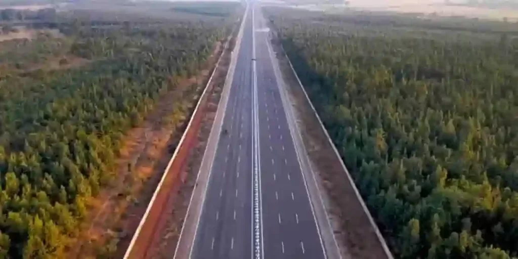
India’s infrastructure revolution accelerates with the Raipur–Visakhapatnam Expressway (NH-130CD), a 464-km six-lane greenfield marvel threading Chhattisgarh’s forests, Odisha’s mineral belts, and Andhra Pradesh’s Eastern Ghats. Slated for December 2026 completion at ₹16,482–20,000 crore under Bharatmala Pariyojana Phase-I, this Economic Corridor (EC-15) shrinks the 595-km NH-26 slog – from 12–13 hours to just 5–7 hours – fueling exports, tourism, and tribal upliftment.Prime Minister Narendra Modi laid the foundation stone in November 2022, igniting construction across 19 packages via the Hybrid Annuity Model (HAM). South Korean firm YONGMA Engineering crafted the Detailed Project Report (DPR), with most stretches under active build by giants like Dilip Buildcon, HG Infra, Adani Transport, and NKC Projects. Tunnels pierce Ghat valleys – a 2.9-km twin bore in Koraput nears 90% completion, boasting jet fans, fire systems, and SOS every 200m.Route Breakdown: From Abhanpur to SabbavaramKicking off at Kurud/Abhanpur (Raipur district) on NH-30/NH-130C/SH-22, it slices southeast:Chhattisgarh (4 districts, ~125 km)Raipur → Dhamtari (Package-1: Abhanpur-Magerlod, Shalimar Corp.)Kanker (Package-2: Sargi-Basanwahi, Dilip Buildcon; via Sarona)Kondagaon (east of Keskal)Border at Marangpuri/Salna (Package-3: KMV Projects)Odisha (2 districts, ~214 km)Nabarangpur (Packages 1–4: Sunapali-Raighar-Umerkote-Nabarangpur; NKC, Barbrik, Adani)Koraput (Packages 5–11: Borigumma-Dasamantpur-Koraput-Sunabeda-Pottangi; HG Infra, DRA Infracon; 3 pending notices). Tunnels and noise barriers shield Indravati National Park greenery.Andhra Pradesh (Vizianagaram-Visakhapatnam, ~125 km)Parvathipuram Manyam-Vizianagaram (Packages 1–3: Aluru-Jakkuva-Korlam-Kantakapalle; HG Infra, NKC, PSK)Ends at Sabbavaram Interchange on NH-16 Golden Quadrilateral, linking Visakhapatnam Port. ROB over Araku rail line; land hurdles linger in final stretches.Access-controlled for 100 km/h speeds, it hugs NH-26 strategically, with sustainable medians, tree-lined edges, and Ghat eco-shields.SectionLength (km)Key PackagesProgress NotesChhattisgarh~1251–3Viaducts, earthwork advancingOdisha~2141–11Koraput tunnels 70–90%; Nabarangpur 70%AP~1251–4Interchange/Fastag ready; land acquisition delaysEconomic Lifeline: Ports, Minerals, and MarketsTethering Raipur’s steel-coal hub to Vizag Port slashes logistics costs, supercharging exports to East Asia (China, Japan, Korea). Mineral-rich Chhattisgarh-Odisha gain freight efficiency; industries sprout along spurs. Farmers hail land value surges – from ₹15 lakh/acre to ₹1.5 crore – with fair compensation fueling hope: “What we lost turns into a better future,” says Vizianagaram’s Srinivasulu. Truckers like Vishal foresee day trips: “One-and-a-half days to nighttime arrivals.” PM Gati Shakti vision integrates it with East Coast Corridor (Kolkata-Kanyakumari).infra.Tourism and Tribal TransformationUnlocks Dandakaranya’s hidden gems: Araku Valley coffee trails, Sitanadi/Indravati sanctuaries, Jagdalpur’s Chitrakoot Falls. Remote spots like Kanker, Koraput, and Borigumma integrate via faster access to markets/services, spawning jobs in hospitality, realty, and agro-processing.Future Web: National and Global ReachBharatmala spurs eye NCR-CMC links: Bathinda-Hisar-Jaipur-Gwalior (Chambal bridges); Ludhiana-Patiala-Narnaul-Alwar; Paradeep-Raxaul Eastern Corridor loop. Ties to Delhi-Mumbai Expressway, Yamuna Eway, Amritsar-Jamnagar – even Nepal – forge a pan-India artery.As cranes hum near Kothavalasa bridges, this corridor embodies Bharat’s build: not roads, but rivers of opportunity carving equity from terrain. By 2026, Raipur-Vizag won’t just connect – it’ll catalyze destinies.
Atal Setu: India’s Longest Sea Bridge Transforming Mumbai’s Connectivity
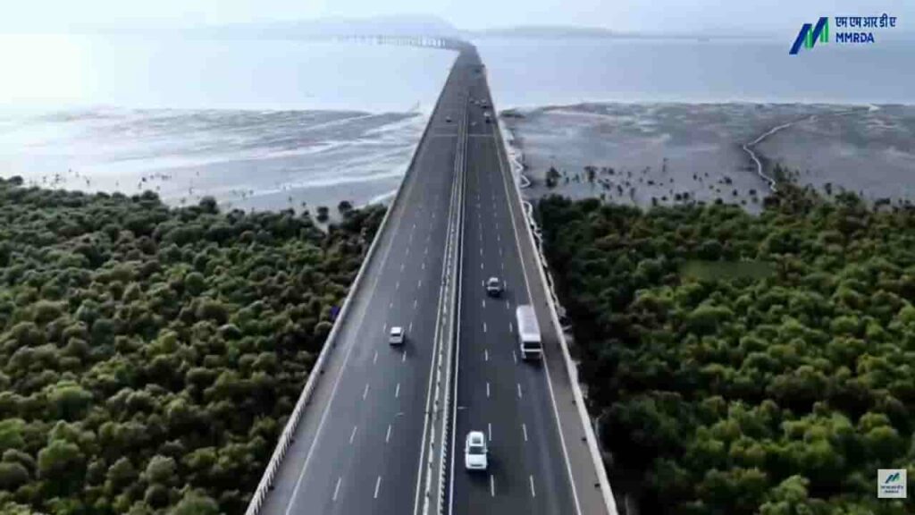
IntroductionThe Atal Setu, officially known as the Mumbai Trans Harbour Link, is one of India’s most remarkable infrastructure achievements. Connecting Mumbai with Navi Mumbai, this sea bridge has significantly transformed travel across the Mumbai Metropolitan Region.Inaugurated in January 2024, the project stands as India’s longest sea bridge and represents a major milestone in enhancing urban mobility, reducing congestion, and supporting economic growth in one of the country’s busiest regions.Project OverviewThe Atal Setu stretches approximately 21.8 kilometres, of which around 16.5 kilometres lies over the Arabian Sea. Developed by the Mumbai Metropolitan Region Development Authority, the bridge connects Sewri in Mumbai to Nhava Sheva in Navi Mumbai.Designed as a six-lane access-controlled expressway, the bridge allows high-speed travel and provides a direct link between South Mumbai and key areas such as:Navi MumbaiJawaharlal Nehru Port TrustNavi Mumbai International Airport (upcoming)This strategic alignment makes the bridge a critical infrastructure asset for both passenger and cargo movement.Need and Strategic ImportanceBefore the construction of Atal Setu, connectivity between Mumbai and Navi Mumbai relied heavily on longer routes via Thane or Vashi, often leading to heavy congestion and extended travel times.The bridge was conceptualised to:Provide a faster alternative routeReduce traffic burden on existing corridorsImprove connectivity to ports and upcoming infrastructure projectsIt is expected to reduce travel time between Sewri and Nhava Sheva from nearly two hours during peak traffic to about 20 minutes.Engineering Excellence and DesignSpecial materials and coatings were used to ensure durability and long-term performance.Intelligent Transport SystemsThe bridge is equipped with modern traffic management systems, including:Speed monitoring camerasEmergency response systemsSurveillance infrastructureThese features enhance safety and ensure smooth traffic flow.Safety RestrictionsTo maintain safety, certain categories of vehicles such as two-wheelers, auto-rickshaws, and tractors are restricted from using the bridge.Economic and Urban ImpactThe Atal Setu is expected to play a transformative role in the economic and urban development of the Mumbai Metropolitan Region.Boost to Logistics and TradeWith improved access to Jawaharlal Nehru Port Trust, India’s largest container port, the bridge enhances the efficiency of cargo transportation and logistics operations.Real Estate and Urban ExpansionThe project is expected to accelerate development in Navi Mumbai, making it a more attractive destination for residential and commercial investment.Airport ConnectivityThe bridge provides seamless access to the upcoming Navi Mumbai International Airport, strengthening regional connectivity.The Atal Setu is a testament to advanced engineering and modern construction techniques.Sea Bridge ConstructionBuilding a long bridge over open sea posed several challenges, including:Strong tidal currentsCorrosion due to saline conditionsEnvironmental constraintsEnvironmental ConsiderationsGiven its location over the sea, the project required careful environmental planning.Measures included:Minimising impact on marine ecosystemsMonitoring coastal biodiversityAdhering to environmental regulationsDespite these efforts, environmental concerns were raised during the planning and construction phases, particularly regarding potential effects on marine life.Challenges During ConstructionThe construction of Atal Setu involved multiple challenges:Working in deep-sea conditionsManaging logistics for large-scale constructionEnsuring minimal disruption to shipping routesDelays due to environmental clearances and pandemic-related disruptionsDespite these obstacles, the project was completed through coordinated efforts and advanced engineering solutions.Integration with Other Infrastructure ProjectsThe Atal Setu is part of a broader infrastructure network aimed at improving connectivity in the Mumbai region. It complements:Mumbai Coastal Road ProjectNavi Mumbai International AirportExisting highway and rail networksThis integrated approach enhances overall transport efficiency and supports regional growth.Final PerspectiveThe Atal Setu stands as a landmark achievement in India’s infrastructure development, symbolising innovation, scale, and ambition. By drastically reducing travel time and improving connectivity between Mumbai and Navi Mumbai, it has reshaped commuting patterns and opened new avenues for economic expansion.More than just a bridge, Atal Setu represents a critical link in India’s journey towards building world-class infrastructure that supports both urban growth and national development.
Samruddhi Mahamarg: Maharashtra’s High-Speed Economic Corridor
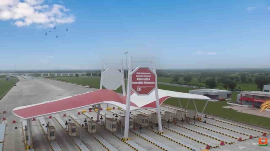
IntroductionThe Hindu Hrudaysamrat Balasaheb Thackeray Maharashtra Samruddhi Mahamarg, commonly known as the Samruddhi Mahamarg, is one of India’s most ambitious expressway projects aimed at transforming connectivity and economic development across Maharashtra. Designed as a high-speed, access-controlled corridor, the expressway connects the state capital Mumbai with Nagpur, significantly reducing travel time and boosting regional growth.The project represents a major step in strengthening infrastructure while promoting balanced development across urban and rural regions of the state.Project Overview and RouteThe Samruddhi Mahamarg spans approximately 701 kilometres, making it one of the longest expressways in India. It passes through 10 districts and connects key regions including Nashik, Aurangabad (now Chhatrapati Sambhajinagar), and Amravati.The expressway has been developed by the Maharashtra State Road Development Corporation and is designed for high-speed vehicular movement, with a maximum speed limit of up to 120 km/h.The corridor begins near Mumbai and stretches eastward to Nagpur, creating a direct and efficient link between the two major cities.Need and Vision Behind the ProjectBefore the construction of the Samruddhi Mahamarg, travel between Mumbai and Nagpur could take up to 16–18 hours due to traffic congestion and road conditions. The need for a faster, safer, and more efficient route was critical for both passenger and freight movement.The vision behind the project goes beyond connectivity. It aims to create an “economic corridor” by:Linking underdeveloped regions with major marketsPromoting industrial and agricultural growthEncouraging investment along the routeThe expressway is expected to serve as a backbone for regional development in Maharashtra.Key Features and DesignThe Samruddhi Mahamarg incorporates modern infrastructure and safety features to ensure smooth and secure travel.Access-Controlled ExpresswayThe highway is fully access-controlled, meaning vehicles can enter and exit only at designated interchanges. This reduces traffic interruptions and enhances safety.High-Speed CorridorWith multiple lanes and a high design speed, the expressway enables faster travel compared to traditional highways.Advanced Safety MeasuresThe project includes:Wildlife crossings and underpassesEmergency response systemsSurveillance and monitoring infrastructureThese measures aim to minimise accidents and ensure passenger safety.Smart InfrastructureThe expressway is equipped with intelligent traffic management systems, making it one of the technologically advanced road projects in India.Economic Impact and Development PotentialThe Samruddhi Mahamarg is expected to have a transformative impact on Maharashtra’s economy.Boost to Trade and LogisticsBy reducing travel time and transportation costs, the expressway enhances the efficiency of goods movement across the state.Industrial GrowthThe government has planned the development of industrial hubs, logistics parks, and smart cities along the corridor. These developments are expected to attract investment and generate employment.Agricultural BenefitsFarmers in rural regions will gain better access to markets, reducing wastage and increasing income opportunities.Progress and ImplementationThe expressway has been opened in phases, with major sections becoming operational between 2022 and 2024. By 2024, the full stretch connecting Mumbai and Nagpur was largely completed and made accessible to the public.The phased approach allowed for gradual integration of the expressway into the state’s transport network while ensuring quality construction.Environmental and Social ConsiderationsGiven the scale of the project, environmental and social impacts have been closely monitored.Land AcquisitionThe project required acquisition of land across multiple districts, which involved compensation and rehabilitation of affected communities.Environmental MeasuresEfforts have been made to:Develop green belts along the expresswayProvide wildlife crossings in forest areasMinimise ecological disruptionDespite these efforts, concerns have been raised about environmental impact and land use changes.Challenges FacedThe development of the Samruddhi Mahamarg encountered several challenges:Large-scale land acquisitionCoordination across multiple districtsEnvironmental clearancesConstruction during the COVID-19 pandemicHowever, the project was completed through coordinated efforts between government agencies and contractors.Strategic ImportanceThe expressway is not just a transport project but a strategic infrastructure initiative that strengthens Maharashtra’s position as an economic powerhouse.By connecting major cities and emerging regions, it supports:Balanced regional developmentImproved connectivity to ports and industrial zonesIntegration with national highway networksFinal PerspectiveThe Samruddhi Mahamarg stands as a landmark achievement in India’s infrastructure development. By drastically reducing travel time between Mumbai and Nagpur and creating new economic opportunities along its route, the project has redefined connectivity in Maharashtra.More importantly, it reflects a broader shift towards building infrastructure that not only facilitates movement but also drives inclusive growth, linking cities, industries, and rural communities into a unified economic corridor.
Parvatmala Project: India’s National Ropeway Development Programme
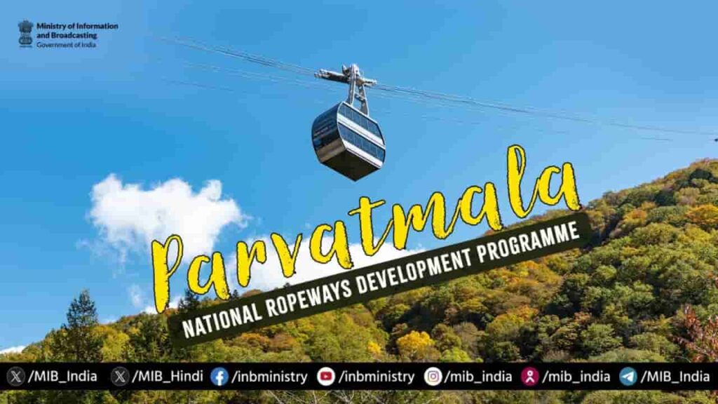
Image: MIBIntroductionThe Parvatmala Project, officially known as Parvatmala Pariyojana, was announced in the Union Budget 2022–23 as a major initiative to develop ropeway infrastructure across India, particularly in hilly and mountainous regions. The project aims to provide safe, efficient and sustainable connectivity in areas where traditional road and rail infrastructure face geographical and environmental challenges.It is being implemented under the guidance of the Ministry of Road Transport and Highways, with a strong focus on boosting connectivity, tourism, and local economic activity.Vision and ObjectivesThe core vision of the Parvatmala Project is to transform mobility in difficult terrains by introducing ropeways as a viable alternative to conventional transport systems. In many hill regions, road construction is not only expensive but also environmentally disruptive. Ropeways offer a cleaner and more efficient solution.The project is designed to:Improve last-mile connectivity in remote and hilly areasReduce travel time significantlyPromote eco-friendly transportationBoost tourism in scenic destinationsBy focusing on these objectives, the initiative seeks to integrate remote regions more effectively into the mainstream economy.Implementation StrategyThe Parvatmala Project is being developed under the Public-Private Partnership (PPP) model, which allows private players to participate in financing, constructing, and operating ropeway systems.The government has identified multiple corridors across states such as Uttarakhand, Himachal Pradesh, Jammu & Kashmir, and the Northeast for ropeway development. These routes are selected based on their tourism potential, connectivity needs, and feasibility.The project is expected to be implemented in phases, with initial priority given to high-demand routes and pilgrimage circuits.Key Features of Ropeway SystemsRopeways under the Parvatmala Project are expected to offer several advantages over traditional transport:They are designed to operate in difficult terrains with minimal land use, reducing the need for large-scale construction. Travel through ropeways is significantly faster, especially in areas where road journeys can take several hours due to winding routes.Additionally, ropeways are considered environmentally sustainable, as they produce lower emissions compared to fuel-based transport systems. They also help in reducing traffic congestion in popular tourist destinations.Economic and Tourism ImpactOne of the major expected outcomes of the Parvatmala Project is the boost to tourism. Improved connectivity to hill stations, धार्मिक sites, and remote scenic locations can increase tourist footfall and generate employment opportunities for local communities.The project is also likely to:Support small businesses in remote areasEnhance accessibility for pilgrims and touristsCreate jobs in construction, operations, and maintenanceBy improving connectivity, the initiative can play a key role in regional economic development.Challenges and ConcernsDespite its potential, the Parvatmala Project faces several challenges. Land acquisition, environmental clearances, and coordination between multiple agencies can slow down implementation.There are also concerns regarding the financial viability of certain routes, especially in areas with seasonal tourist demand. Ensuring safety standards and maintenance of ropeway systems will be critical for long-term success.The Road AheadThe government aims to develop over 200 ropeway projects covering more than 1,200 km in the coming years under the Parvatmala initiative. As implementation progresses, the focus will be on balancing infrastructure development with environmental sustainability.Successful execution of the project will depend on efficient planning, strong private sector participation, and timely clearances.ConclusionThe Parvatmala Project represents a significant shift in India’s approach to infrastructure development in mountainous regions. By introducing ropeways as a mainstream mode of transport, the initiative offers a practical solution to long-standing connectivity challenges.If implemented effectively, it has the potential to not only transform mobility in hilly areas but also drive tourism and economic growth, making remote regions more accessible and integrated with the rest of the country.
Sonamarg Tunnel: A Key Milestone in Jammu and Kashmir’s All-Weather Connectivity
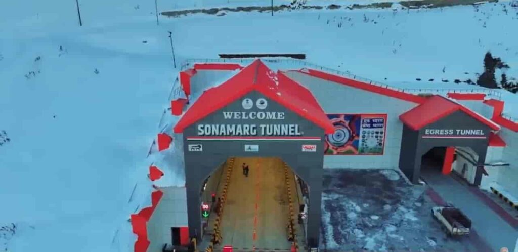
The Sonamarg Tunnel, officially known as the Z-Morh Tunnel, marked a significant step in improving infrastructure in Jammu and Kashmir. Built along the strategic Srinagar–Leh highway, the tunnel has addressed one of the region’s long-standing challenges—seasonal isolation of Sonamarg due to extreme weather conditions.For decades, Sonamarg remained cut off during winters as heavy snowfall and avalanches made the route unsafe and often impassable. The opening of this tunnel has fundamentally changed that reality, ensuring smoother, safer, and uninterrupted connectivity.Overcoming a Long-Standing Connectivity ChallengeLocated between Gagangir and Sonamarg, the tunnel bypasses a particularly vulnerable stretch of road that was notorious for landslides, avalanches, and sharp turns. This stretch, often referred to as the “Z-Morh” due to its winding shape, posed serious risks to travellers and frequently led to prolonged road closures.With the tunnel now operational, the dependency on weather conditions has been significantly reduced. What was once a seasonal route has now been transformed into an all-weather corridor, ensuring that Sonamarg remains accessible throughout the year.Engineering in Extreme TerrainConstructing the tunnel in the Himalayan region was a complex and demanding task. The area is characterised by fragile geology, sub-zero temperatures, and unpredictable weather patterns, all of which posed challenges during construction.The tunnel stretches approximately 6.5 kilometres and has been designed as a modern, two-lane passage capable of handling bi-directional traffic efficiently. Advanced tunnelling techniques were used to cut through the mountainous terrain, while maintaining structural stability and safety.In addition to the main tunnel, extensive work was carried out on approach roads and protective structures to safeguard the route from avalanches and falling debris.Safety and Modern InfrastructureThe Sonamarg Tunnel has been equipped with several modern safety systems to ensure a secure travel experience. Continuous ventilation ensures air quality inside the tunnel, while surveillance systems allow real-time monitoring of traffic movement.Emergency response mechanisms, including escape routes and communication systems, have been integrated into the design. These features are particularly important given the tunnel’s location in a remote and high-altitude region, where immediate external assistance may not always be available.Boost to Tourism and Local EconomyOne of the most immediate impacts of the tunnel has been on tourism. Sonamarg, often called the “Meadow of Gold,” is one of the most scenic destinations in Jammu and Kashmir, but its accessibility was limited to a few months each year.With year-round connectivity now possible, the region is expected to witness a steady increase in tourist inflow. This will directly benefit local businesses, including hotels, transport operators, and small vendors who rely heavily on seasonal tourism.The tunnel has also improved the movement of goods and services, contributing to better economic stability for local communities.Strategic Importance and Connectivity to LadakhBeyond tourism, the tunnel plays a crucial role in enhancing connectivity towards Ladakh. The Srinagar–Leh highway is of significant strategic importance, particularly for defence movement and logistics.By ensuring smoother and more reliable access along this route, the Sonamarg Tunnel strengthens both civilian and strategic mobility in the region. It also complements larger infrastructure projects such as the Zojila Tunnel, which aims to further enhance all-weather connectivity between Srinagar and Leh.Transforming Travel in the RegionThe experience of travelling to Sonamarg has changed considerably with the opening of the tunnel. Journeys that were once uncertain and weather-dependent have become more predictable and safer.Reduced travel time, improved road safety, and uninterrupted access have collectively enhanced the overall connectivity of the region. This shift is expected to play a long-term role in integrating remote areas with mainstream economic and social networks.The Sonamarg Tunnel stands as a testament to India’s growing capability in executing complex infrastructure projects in challenging terrains. By addressing both connectivity and safety concerns, it has not only improved access to a key tourist destination but also contributed to the broader goal of regional development in Jammu and Kashmir.
Kumar Bhaskar Varma Bridge Over Brahmaputra River: Strengthening Connectivity in Assam
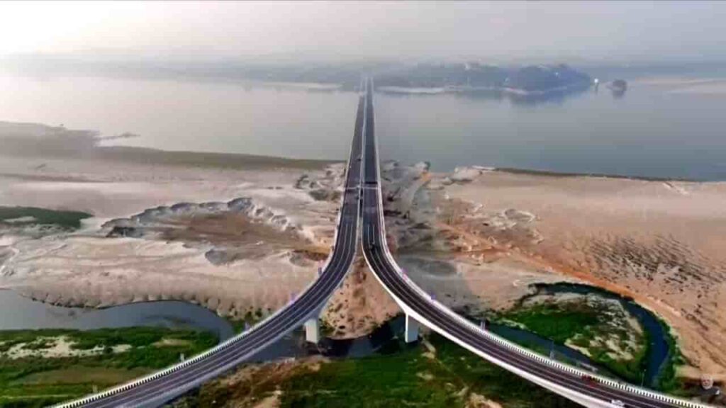
The construction and development of the Kumar Bhaskar Varma Bridge over the Brahmaputra River marks a significant step in enhancing connectivity across Assam. Named after the ancient ruler Kumar Bhaskar Varma, the bridge stands as both an infrastructure milestone and a tribute to the region’s historical legacy.Strategically located, the bridge connects the north and south banks of the Brahmaputra, addressing long-standing challenges of transportation in one of India’s most geographically complex regions.Strategic Location and ImportanceThe Kumar Bhaskar Varma Bridge is being developed near Tezpur, a crucial urban centre in Assam. The Brahmaputra, known for its vast width and unpredictable flow, has historically posed a barrier to seamless connectivity between regions on either side.By linking key districts across the river, the bridge is expected to significantly reduce travel time and improve accessibility for both passengers and goods transport. It will serve as an important alternative route to existing crossings, easing pressure on older bridges and ferry services.Enhancing Regional ConnectivityConnectivity has long been a challenge in Assam, particularly in areas separated by the Brahmaputra. The new bridge aims to transform this by providing:Faster inter-district travelImproved access to healthcare and education facilitiesBetter connectivity for rural and semi-urban areasStrengthened road networks linking national highwaysThe bridge will play a vital role in integrating remote regions with major economic centres, thereby supporting inclusive development.Boost to Trade and Economic ActivityThe project is expected to have a strong economic impact on the region. Assam’s economy relies heavily on agriculture, tea production, and small-scale industries, all of which depend on efficient transportation.With improved connectivity:Movement of goods will become faster and more cost-effectiveTrade between northern and southern Assam will increaseLocal businesses will gain better access to marketsTourism in nearby regions will receive a boostThe bridge is also likely to support cross-border trade routes in the broader Northeast region.Engineering and Infrastructure SignificanceConstructing a bridge over the Brahmaputra is a complex engineering challenge due to the river’s strong currents, shifting channels, and seasonal flooding. The Kumar Bhaskar Varma Bridge reflects advancements in modern engineering techniques designed to withstand such conditions.The structure is expected to feature:Multiple spans to accommodate the river’s widthHigh load-bearing capacity for heavy vehiclesDurable materials suited for flood-prone conditionsSafety features for all-weather usageSuch infrastructure is crucial for ensuring year-round connectivity in a region often affected by monsoon disruptions.Social and Developmental ImpactBeyond economic benefits, the bridge will have a meaningful social impact. Improved connectivity often translates into better quality of life for local communities.Residents will experience:Easier access to hospitals and emergency servicesGreater educational opportunitiesEnhanced mobility for daily commutingReduced isolation of remote areasFor many communities, the bridge represents not just infrastructure, but improved access to essential services and opportunities.Cultural and Historical SignificanceNaming the bridge after Kumar Bhaskar Varma adds a cultural dimension to the project. He was a prominent ruler of the ancient Kamarupa kingdom and is remembered for his contributions to the region’s history.The naming reflects an effort to connect modern development with historical identity, preserving regional pride while moving forward with infrastructure growth.Toward a More Connected NortheastThe Kumar Bhaskar Varma Bridge is part of a broader push by the government to improve infrastructure across Northeast India. Enhanced connectivity is seen as a key driver for economic growth, national integration, and strategic development in the region.As Assam continues to expand its transport network, projects like this bridge are expected to play a central role in shaping the state’s future—bringing regions closer, improving mobility, and unlocking new opportunities across sectors.
India’s First Wildlife-Friendly Highway Stretch Developed on NH-45 in Madhya Pradesh
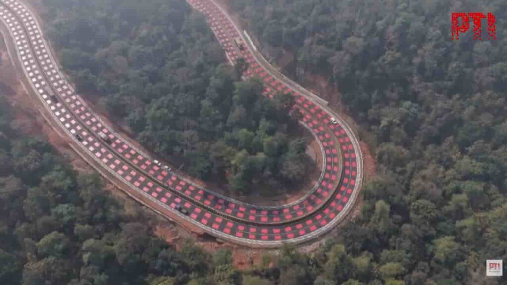
Image: PTIIndia has introduced its first wildlife-friendly highway stretch on National Highway-45 (NH-45) in Madhya Pradesh, marking an important step toward balancing infrastructure development with wildlife conservation. The initiative has been implemented by the National Highways Authority of India to reduce animal-vehicle collisions in ecologically sensitive forest corridors.The project covers an 11.96-kilometre stretch on the Hiran–Sindoor section of NH-45, which connects Bhopal and Jabalpur and passes through the Veerangana Durgavati Tiger Reserve. The corridor also lies close to the Nauradehi Wildlife Sanctuary, making it an important route for wildlife movement between forest habitats.Innovative “Table-Top” Red MarkingsA key feature of the wildlife-friendly highway is the introduction of “table-top red road markings.” These markings consist of 5-millimetre thick thermoplastic red layers applied across the road surface in areas where wildlife movement is frequent.The raised texture of these markings creates mild vibrations and audible feedback when vehicles pass over them. This tactile and visual cue encourages drivers to slow down naturally without requiring abrupt braking. The bright red colour also serves as a warning that the vehicle is entering a wildlife-sensitive zone.The design was inspired by similar traffic-calming techniques used on the Sheikh Zayed Road in Dubai, where road engineering solutions are used to control vehicle speeds in specific areas.Infrastructure for Wildlife ProtectionIn addition to the innovative road markings, the highway corridor includes several other features aimed at protecting wildlife.Authorities have constructed 25 dedicated wildlife underpasses along the stretch to allow animals to move safely beneath the road. Continuous fencing has also been installed along both sides of the highway to guide animals toward these crossing points and prevent them from wandering onto the roadway.Cameras and monitoring systems have also been installed at certain locations to track wildlife movement and ensure that the safety measures remain effective.Importance of the InitiativeThe NH-45 corridor passes through a forest ecosystem that supports a variety of wildlife species, including tigers, deer, sambar and jackals. Increased traffic on highways running through such habitats often leads to animal-vehicle collisions, posing risks both to wildlife and motorists.The wildlife-friendly highway design aims to reduce these incidents by encouraging slower driving and providing safe crossing infrastructure for animals.A Model for Sustainable Highway DevelopmentThe project is part of the government’s broader push toward environmentally responsible infrastructure under initiatives such as the Green Highways Policy. If successful, the model could be replicated on other national highways that pass through wildlife corridors and protected forest areas.Experts believe that integrating wildlife-friendly features into road design is essential as India continues expanding its highway network while also preserving its biodiversity.