


GAGAN: India’s Indigenous Navigation Shield for Safer Skies and Smarter Mobility
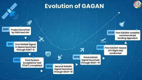
GAGAN, short for GPS Aided GEO Augmented Navigation, is one of India’s most important but least publicly understood technology achievements: a homegrown satellite-based augmentation system that strengthens GPS, improves aviation safety, and extends precise navigation far beyond the airport runway. Developed jointly by ISRO and the Airports Authority of India, it has been operational since 2015 and now sits at the heart of India’s indigenous navigation ecosystem.What makes GAGAN significant is not just that it improves location accuracy, but that it gives pilots integrity information — a real-time warning if a GPS signal should not be trusted for navigation. That single capability changes aviation from “roughly informed” to “safety-certified,” and it is why GAGAN has become a strategic pillar for Indian civil aviation and a symbol of technological self-reliance.Why GAGAN Was NeededModern aviation depends on precision, and even small positioning errors can become serious safety risks when aircraft are landing, flying in bad weather, or operating in crowded airspace. Standard GPS is helpful, but its signals can be distorted by atmospheric conditions and other sources of error, making it insufficient on its own for precision approach and landing.India’s answer was GAGAN, a Satellite-Based Augmentation System, or SBAS, that overlays correction data on top of GPS. Instead of replacing GPS, it makes GPS trustworthy enough for safety-of-life aviation applications by improving accuracy, continuity, availability, and integrity.How GAGAN WorksGAGAN operates through a tightly linked network of ground stations, control centers, uplink stations, communication networks, and geostationary satellites carrying GAGAN payloads. According to ISRO’s URSC, the system includes 15 Indian Reference Stations, 2 Indian Master Control Centres, 3 Indian Land Uplink Stations, 4 communication network chains, and 3 GEO satellites with GAGAN payloads.The process is elegant in concept and highly sophisticated in practice. Reference stations across India continuously monitor GPS signals, master control centers calculate corrections and integrity data, and uplink stations send that information to geostationary satellites, which then broadcast enhanced navigation signals back to aircraft and other users.Core System ElementsElementCountFunctionIndian Reference Stations (INRES)15Monitor GPS signals and detect errors. Indian Master Control Centres (INMCC)2Process data and generate corrections. Indian Land Uplink Stations (INLUS)3Send correction data to satellites. Communication Networks4Support secure real-time transmission. Geostationary satellites with GAGAN payloads3Broadcast corrected navigation signals. Because the satellites are geostationary, they appear fixed in the sky relative to the Earth’s rotation, which makes them ideal for steady regional augmentation services. The currently cited GAGAN payload satellites include GSAT-8, GSAT-10, and GSAT-15.Aviation Breakthrough & Global StandingGAGAN’s biggest job is to make Indian aviation safer and more efficient, especially during non-precision and precision approach procedures. ISRO’s documentation notes that the system has been certified to provide Non Precision Approach services over the Indian Flight Information Region and APV services over Indian landmass, bringing India into the select club of countries with operational SBAS capability.The significance became especially clear in June 2026, when DGCA successfully conducted India’s first satellite-based landing system approach on a commercial jet using GAGAN. That milestone was not just symbolic; it demonstrated that India can now rely on an indigenous augmentation system for advanced approach operations, reducing dependence on foreign navigation ecosystems.GAGAN places India alongside the United States, Europe, and Japan, which operate comparable augmentation systems such as WAAS, EGNOS, and MSAS. It is also interoperable with those international systems, which matters in global aviation because aircraft often cross multiple airspace regions and must move seamlessly between standards and navigation services.Another important distinction is that GAGAN is described as the first SBAS certified for the equatorial anomaly region, a technically challenging zone where ionospheric conditions can affect satellite navigation. That makes the system especially valuable not only for India but for the broader region extending well beyond the country’s borders.GAGAN vs NavICGAGAN is often mentioned alongside NavIC, but the two systems serve different purposes. NavIC is India’s independent regional navigation satellite system, providing positioning, navigation, and timing services across India and up to about 1,500 km beyond its borders, while GAGAN augments GPS with correction and integrity information for aviation-grade precision.Think of NavIC as an independent navigation backbone and GAGAN as the precision safety layer that helps GPS become reliable enough for demanding civil aviation use. Together, they form a stronger indigenous navigation stack that reduces dependence on external systems while expanding India’s strategic autonomy.Uses Beyond AviationAlthough GAGAN was created for civil aviation, its usefulness extends into several other sectors. The URSC notes applications in maritime navigation, highways, railways, disaster management, defense, telecom synchronization, surveying, and public services.That broader utility is important because navigation infrastructure has become a foundation for modern digital economies. Precise timing supports telecom networks, accurate positioning improves logistics and fleet management, and reliable geospatial data strengthens everything from mapping to emergency response.Strategic Value for IndiaGAGAN is more than a technical system; it is a statement of capability. By building and operating its own SBAS, India has created a sovereign navigation asset that improves safety, supports aviation growth, and enhances resilience in a world where critical infrastructure increasingly depends on space-based signals.The system also fits neatly into India’s broader aviation and technology ambitions. As civil aviation expands and the government pushes for more airports, stronger regional connectivity, and advanced air traffic management, GAGAN provides an indigenous precision layer that can support those goals for years to come.The Road AheadThe next phase for GAGAN is likely to be defined by wider adoption, deeper integration with aviation operations, and more cross-sector use. Its ability to support precision approaches, landing operations, and reliable positioning services makes it a key enabler for a future in which Indian infrastructure is increasingly digital, connected, and self-reliant.In practical terms, GAGAN helps India do something important: turn space technology into everyday public value. It makes flights safer, navigation smarter, and national capability stronger, all while quietly proving that indigenous systems can meet the highest international standards.ConclusionGAGAN is one of India’s clearest examples of technology serving both safety and sovereignty. Developed by ISRO and AAI, certified to international civil aviation standards, and now proven in satellite-based landing operations, it has transformed from an engineering project into